Load HEC-RAS 1D Geometry Layers
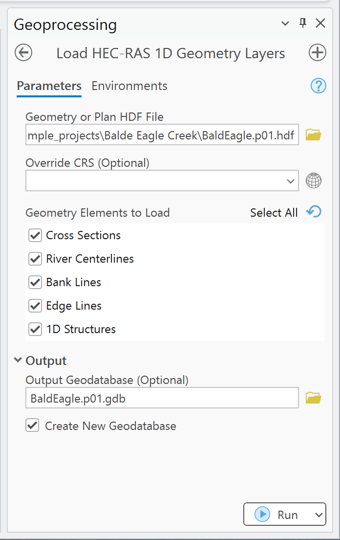
Use this tool to create ArcGIS feature classes from supported 1D geometry stored in a HEC-RAS geometry or plan HDF file.
Before you run it
- Select a
g*.hdforp*.hdfthat contains 1D geometry. - Prefer a plan HDF when the output must be clearly associated with a specific plan.
- Confirm the project coordinate system in HEC-RAS/RAS Mapper.
- Choose a writable file geodatabase for durable output.
Parameters
| Parameter | Required | Behavior |
|---|---|---|
| Geometry or Plan HDF File | Yes | Reads supported geometry from a HEC-RAS g*.hdf or p*.hdf. |
| Override CRS | No | Used only when the tool cannot determine a projection from the project context. It does not reproject a detected CRS. |
| Geometry Elements to Load | Yes | Multi-select list. Defaults to Cross Sections and River Centerlines. |
| Output Cross Sections | Conditional | Enabled when cross sections are selected. Default is memory\CrossSections. |
| Output River Centerlines | Conditional | Enabled when river centerlines are selected. |
| Output Bank Lines | Conditional | Enabled when bank lines are selected. |
| Output Edge Lines | Conditional | Enabled when edge lines are selected. |
| Output 1D Structures | Conditional | Enabled when 1D structures are selected. |
| Output Geodatabase | No | Destination file geodatabase. With automatic creation, defaults beside the HDF as Project.pXX.gdb. |
| Create New Geodatabase | No | Enabled by default. Creates/reuses the named geodatabase and writes outputs to a plan feature dataset. |
Procedure
- Open Load HEC-RAS 1D Geometry Layers.
- Select the geometry or plan HDF.
- If the tool reports that the CRS cannot be determined, set Override CRS to the confirmed project coordinate system.
- Select only the elements needed for the current review.
- Keep Create New Geodatabase enabled for persistent output, or explicitly set each output.
- Run the tool and review the geoprocessing messages.
- Confirm the output location, coordinate system, feature count, and spatial alignment.
Outputs
| Selection | Geometry | Feature class in organized output | Key fields |
|---|---|---|---|
| Cross Sections | Polyline | CrossSections |
xs_id, River, Reach, RS, bank stations, reach lengths, StationElevation, ManningsN |
| River Centerlines | Polyline | RiverCenterlines |
river_id, RiverName, ReachName, USType, DSType |
| Bank Lines | Polyline | BankLines |
bank_id, BankSide, Length |
| Edge Lines | Polyline | EdgeLines |
edge_id, EdgeType, Length |
| 1D Structures | Polyline | Structures1D |
struct_id, Type, River, Reach, RS, Description |
StationElevation and ManningsN are text attributes in the GIS output. Use the source HEC-RAS
model or the full RAS Commander APIs when complete arrays or editing workflows are required.
Interpretation notes
- The tool skips an element when its required HDF group/dataset is absent and reports a message.
- Structure support depends on geometry stored under the HEC-RAS
Geometry/StructuresHDF group. - Output coordinates are assigned the detected/selected CRS; the tool does not transform source coordinates between CRSs.
- Geometry extraction is read-only. No HEC-RAS file is modified.
Common checks
- Compare cross-section stationing and reach association with the Geometry editor.
- Check bank/edge-line orientation and extent against the terrain and centerline.
- Confirm that structure count and river station values match the intended geometry.
- If the output is empty, inspect Troubleshooting.
See Outputs and naming for geodatabase conventions.