Model Extent Polygons (1D, 2D, and Overall Footprints)
HEC-RAS models cover a real footprint on the ground: the perimeters of the 2D flow areas plus the corridor swept by the 1D cross sections. This notebook shows how to build those footprints as true polygons directly from the geometry HDF, rather than a rectangular bounding box.
What you'll learn
- Read 2D flow-area perimeters with
HdfMesh.get_mesh_areas(). - Generate 1D river edge lines from cross-section end points with
HdfXsec.generate_river_edge_lines()(the pure-Python equivalent of RASMapper's Create Edge Lines at XS Limits). - Build the 1D reach footprint polygon(s) with
HdfXsec.get_1d_footprint(). - Get the true model extent polygon (1D + 2D, multipart) from the upgraded
HdfProject.get_project_extent(..., geometry_type='footprint'), and compare it to the legacy buffered bounding box. - Slice the extent into 1D-only and 2D-only footprints with the
include_1d/include_2dflags.
Prerequisites
ras-commanderwithgeopandas/shapely(installed dependencies).- Internet access on first run (downloads the HEC-RAS example projects).
- No HEC-RAS execution is required — everything is read from the geometry HDF.
import sys
import logging
from pathlib import Path

# Prefer the local repository source so the newest extent APIs are available even
# when an older ras-commander is pip-installed. Walk up from the notebook location
# until we find the package, then put that repo root first on sys.path.
_here = Path.cwd()
for _cand in [_here, *_here.parents]:
    if (_cand / "ras_commander" / "__init__.py").exists():
        sys.path.insert(0, str(_cand))
        break

import matplotlib.pyplot as plt

import ras_commander
from ras_commander import RasExamples, init_ras_project
from ras_commander.hdf import HdfXsec, HdfMesh, HdfProject, HdfStruc

# Quiet the library's informational logging so the demo output stays readable.
# (Geometries without 1D cross sections log a handled error while we scan for the
# right one; real failures still raise exceptions.)
logging.getLogger("ras_commander").setLevel(logging.CRITICAL)

print("ras_commander:", ras_commander.__file__)


def extract_or_reuse(name, suffix):
    """Reuse an already-extracted example project if present, else extract it.

    Keeps notebook re-runs fast; still downloads/extracts on a fresh machine.
    """
    dest = Path.cwd() / "example_projects" / f"{name}_{suffix}"
    if dest.exists() and any(dest.glob("*.prj")):
        return dest
    return RasExamples.extract_project(name, suffix=suffix)


def find_geom_hdfs(project_folder):
    """Return the geometry HDF files (*.g##.hdf) in a project folder, sorted."""
    return sorted(Path(project_folder).glob("*.g[0-9][0-9].hdf"))


def describe(gdf, label):
    """Compact one-line summary of a geometry GeoDataFrame."""
    if gdf is None or len(gdf) == 0:
        print(f"  {label}: (empty)")
        return
    gtypes = sorted(set(gdf.geom_type))
    try:
        area = float(gdf.geometry.area.sum())
    except Exception:
        area = float("nan")
    print(f"  {label}: rows={len(gdf)} types={gtypes} area={area:,.0f} valid={bool(gdf.geometry.is_valid.all())}")
c:\Users\bill\anaconda3\envs\rascommander\Lib\site-packages\tqdm\auto.py:21: TqdmWarning: IProgress not found. Please update jupyter and ipywidgets. See https://ipywidgets.readthedocs.io/en/stable/user_install.html
  from .autonotebook import tqdm as notebook_tqdm


ras_commander: C:\Users\bill\AppData\Local\Temp\rc-extent\ras_commander\__init__.py
Example 1: Combined 1D + 2D model (Bald Eagle Creek Multi-2D)
This model has a 1D river reach and several 2D flow areas, so it exercises every part of the extent API: 2D perimeters, a 1D reach footprint, and the unified overall extent.
project = extract_or_reuse("BaldEagleCrkMulti2D", "extent_demo")
ras = init_ras_project(project, "6.6")

# Pick the geometry HDF that carries both 2D areas and 1D cross sections.
geom_hdf = None
for candidate in find_geom_hdfs(project):
    names = HdfMesh.get_mesh_area_names(candidate)
    xs = HdfXsec.get_cross_sections(candidate)
    if names and not xs.empty:
        geom_hdf = candidate
        break
geom_hdf = geom_hdf or find_geom_hdfs(project)[0]
print("Geometry HDF:", geom_hdf.name)
print("2D area names:", HdfMesh.get_mesh_area_names(geom_hdf))
Geometry HDF: BaldEagleDamBrk.g06.hdf
2D area names: ['193', '194', 'LockHaven']
2D flow-area perimeters
HdfMesh.get_mesh_areas() returns one perimeter polygon per 2D flow area, already
carrying the project CRS. Multiple areas become multiple rows.
mesh_areas = HdfMesh.get_mesh_areas(geom_hdf)
print("CRS:", mesh_areas.crs)
describe(mesh_areas, "2D perimeters (per area)")
mesh_areas[["mesh_name", "geometry"]]
CRS: EPSG:2271
  2D perimeters (per area): rows=3 types=['Polygon'] area=172,401,558 valid=True
| mesh_name | geometry | |
|---|---|---|
| 0 | 193 | POLYGON ((2042744.054 340037.055, 2042059.203 ... |
| 1 | 194 | POLYGON ((2013482.56 332510.738, 2013482.172 3... |
| 2 | LockHaven | POLYGON ((2045454.816 349795.754, 2045592.698 ... |
1D edge lines and the reach footprint
The 1D footprint is the corridor between the left and right edge lines, closed at
each end by the upstream and downstream cross sections. If the geometry already stores
Geometry/River Edge Lines, those are used; otherwise get_1d_footprint() generates
them on the fly from the cross-section end points (generate_river_edge_lines()).
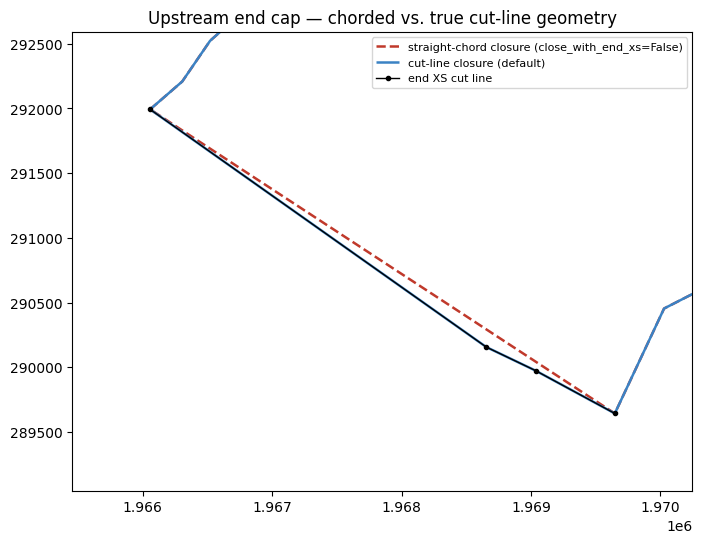
The end caps follow the real cut-line geometry of the end cross sections, interior
vertices included, so a bent cut line is reproduced rather than chorded straight across.
Pass close_with_end_xs=False for the legacy straight-chord closure.
stored_edges = HdfXsec.get_river_edge_lines(geom_hdf)
generated_edges = HdfXsec.generate_river_edge_lines(geom_hdf)
describe(stored_edges, "stored edge lines")
describe(generated_edges, "generated edge lines (fallback)")

# Per-reach footprint polygons, and the dissolved (multipart) version.
footprint_1d = HdfXsec.get_1d_footprint(geom_hdf, dissolve=False)
footprint_1d_dissolved = HdfXsec.get_1d_footprint(geom_hdf, dissolve=True)
describe(footprint_1d, "1D footprint (per reach)")
describe(footprint_1d_dissolved, "1D footprint (dissolved)")
footprint_1d[["River", "Reach", "source", "geometry"]]
  stored edge lines: (empty)
  generated edge lines (fallback): rows=2 types=['LineString'] area=0 valid=True


  1D footprint (per reach): rows=1 types=['Polygon'] area=707,534,339 valid=True


  1D footprint (dissolved): rows=1 types=['Polygon'] area=707,534,339 valid=True
| River | Reach | source | geometry | |
|---|---|---|---|---|
| 0 | Bald Eagle Cr. | Lock Haven | generated_edge_lines | POLYGON ((1966056.938 291992.687, 1966305.15 2... |
Visualizing the edge lines and the 1D extent
The left panel colors the left and right edge lines (bank_side) that bound each reach, with the cross-section cut lines between them and the closed reach footprint underneath. The right panel is the 1D-only extent (get_project_extent(include_2d=False)) over the same cross sections — the corridor the 1D model actually occupies, with no 2D area mixed in.
from matplotlib.lines import Line2D
from matplotlib.patches import Patch

left_edges = generated_edges[generated_edges["bank_side"] == "Left"]
right_edges = generated_edges[generated_edges["bank_side"] == "Right"]
extent_1d, _ = HdfProject.get_project_extent(geom_hdf, include_2d=False, buffer_percent=0.0)
xs_be = HdfXsec.get_cross_sections(geom_hdf)

fig, (axL, axR) = plt.subplots(1, 2, figsize=(13, 6))

# Left: edge lines by bank, cut lines, and the closed reach footprint.
footprint_1d.plot(ax=axL, color="#3b82c4", alpha=0.18, edgecolor="none", zorder=1)
xs_be.plot(ax=axL, color="#999", linewidth=0.5, zorder=2)
left_edges.plot(ax=axL, color="#1f6fb2", linewidth=1.8, zorder=3)
right_edges.plot(ax=axL, color="#c0392b", linewidth=1.8, zorder=3)
footprint_1d.boundary.plot(ax=axL, color="#1b3b5f", linewidth=0.9, zorder=4)
axL.set_title("Left / right edge lines and the reach footprint")
axL.set_aspect("equal")
axL.legend(handles=[
    Patch(facecolor="#3b82c4", alpha=0.18, label="1D reach footprint"),
    Line2D([0], [0], color="#999", linewidth=0.8, label="cross-section cut lines"),
    Line2D([0], [0], color="#1f6fb2", linewidth=1.8, label="left edge line"),
    Line2D([0], [0], color="#c0392b", linewidth=1.8, label="right edge line"),
    Line2D([0], [0], color="#1b3b5f", linewidth=0.9, label="footprint boundary"),
], loc="upper left", fontsize=8)

# Right: the 1D-only extent (dissolved footprint) over the cross sections.
extent_1d.plot(ax=axR, color="#3b82c4", alpha=0.5, edgecolor="#1b3b5f", linewidth=1.2, zorder=1)
xs_be.plot(ax=axR, color="#33455f", linewidth=0.5, zorder=2)
axR.set_title("1D-only extent (include_2d=False)")
axR.set_aspect("equal")
axR.legend(handles=[
    Patch(facecolor="#3b82c4", alpha=0.5, edgecolor="#1b3b5f", label="1D-only extent"),
    Line2D([0], [0], color="#33455f", linewidth=0.8, label="cross-section cut lines"),
], loc="upper left", fontsize=8)
plt.show()

assert not extent_1d.empty and extent_1d.geometry.is_valid.all()
assert set(generated_edges["bank_side"]) == {"Left", "Right"}
n_parts = (len(extent_1d.geometry.iloc[0].geoms)
           if extent_1d.geometry.iloc[0].geom_type == "MultiPolygon" else 1)
print("Edge lines:", len(left_edges), "left,", len(right_edges), "right;",
      "1D-only extent parts:", n_parts)
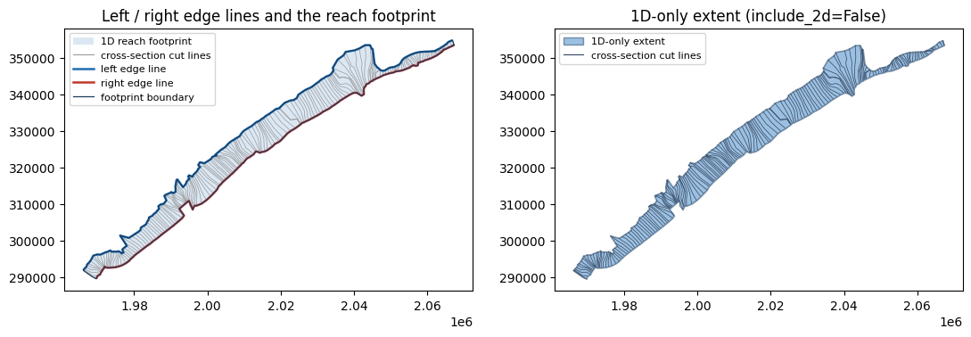
Edge lines: 1 left, 1 right; 1D-only extent parts: 1
How the ends are closed
Zoom in on the upstream end cross section. The straight-chord closure
(close_with_end_xs=False) cuts across the cut line; the default closure walks the cut
line's own vertices, so the footprint ends exactly where the model ends.
chorded = HdfXsec.get_1d_footprint(geom_hdf, close_with_end_xs=False)

xs_all = HdfXsec.get_cross_sections(geom_hdf)
reach_key = (footprint_1d.iloc[0]["River"], footprint_1d.iloc[0]["Reach"])
reach_xs = xs_all[(xs_all["River"] == reach_key[0]) & (xs_all["Reach"] == reach_key[1])]
end_cut = reach_xs.geometry.iloc[0]  # upstream end cross section

print(f"ring vertices  chorded={len(chorded.geometry.iloc[0].exterior.coords)}  "
      f"cut-line closed={len(footprint_1d.geometry.iloc[0].exterior.coords)}")
print(f"end cut line has {len(end_cut.coords)} vertices "
      f"({len(end_cut.coords) - 2} interior)")

# Every interior vertex of the end cut line must appear in the closed ring.
ring = {(round(x, 4), round(y, 4)) for x, y in footprint_1d.geometry.iloc[0].exterior.coords}
interior = [(round(x, 4), round(y, 4)) for x, y in list(end_cut.coords)[1:-1]]
assert all(pt in ring for pt in interior), "end cut-line vertices missing from footprint"
assert footprint_1d.geometry.is_valid.all()
print("\nChecks passed: end cut-line geometry is preserved in the footprint.")

minx, miny, maxx, maxy = end_cut.buffer(600).bounds
fig, ax = plt.subplots(figsize=(8, 6))
chorded.boundary.plot(ax=ax, color="#c0392b", linestyle="--", linewidth=1.8,
                      label="straight-chord closure (close_with_end_xs=False)")
footprint_1d.boundary.plot(ax=ax, color="#3b82c4", linewidth=1.8,
                           label="cut-line closure (default)")
ax.plot(*end_cut.xy, color="black", linewidth=1.0, marker="o", markersize=3,
        label="end XS cut line")
ax.set_xlim(minx, maxx)
ax.set_ylim(miny, maxy)
ax.set_title("Upstream end cap — chorded vs. true cut-line geometry")
ax.set_aspect("equal")
ax.legend(loc="best", fontsize=8)
plt.show()
ring vertices  chorded=385  cut-line closed=388
end cut line has 4 vertices (2 interior)

Checks passed: end cut-line geometry is preserved in the footprint.
The overall model extent (upgraded get_project_extent)
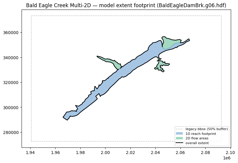
HdfProject.get_project_extent(..., geometry_type='footprint') (the new default)
unions the 2D perimeters with the 1D reach footprints into the true model extent.
Pass buffer_percent=0 for the raw footprint. The include_1d / include_2d flags
carve out the 1D-only and 2D-only extents. For comparison, geometry_type='bbox'
returns the legacy buffered bounding box.
overall, overall_bounds = HdfProject.get_project_extent(geom_hdf, buffer_percent=0.0)
extent_1d_only, _ = HdfProject.get_project_extent(geom_hdf, include_2d=False, buffer_percent=0.0)
extent_2d_only, _ = HdfProject.get_project_extent(geom_hdf, include_1d=False, buffer_percent=0.0)
bbox, bbox_bounds = HdfProject.get_project_extent(geom_hdf, geometry_type="bbox", buffer_percent=50.0)

describe(overall, "overall footprint (1D + 2D)")
describe(extent_1d_only, "1D-only extent")
describe(extent_2d_only, "2D-only extent")
describe(bbox, "legacy bbox (buffered 50%)")

overall_area = float(overall.geometry.area.sum())
bbox_area = float(bbox.geometry.area.sum())
print(f"\nThe true footprint is {bbox_area / overall_area:.1f}x smaller than the bounding box.")

# Sanity checks (the notebook doubles as a functional test).
assert not overall.empty and overall.geometry.is_valid.all()
assert extent_2d_only.geometry.iloc[0].geom_type in ("Polygon", "MultiPolygon")
assert overall_area <= bbox_area
print("\nChecks passed.")
  overall footprint (1D + 2D): rows=1 types=['Polygon'] area=879,976,583 valid=True
  1D-only extent: rows=1 types=['Polygon'] area=707,534,339 valid=True
  2D-only extent: rows=1 types=['MultiPolygon'] area=172,401,558 valid=True
  legacy bbox (buffered 50%): rows=1 types=['Polygon'] area=15,282,299,978 valid=True

The true footprint is 17.4x smaller than the bounding box.

Checks passed.
from matplotlib.lines import Line2D
from matplotlib.patches import Patch

fig, ax = plt.subplots(figsize=(9, 8))
bbox.boundary.plot(ax=ax, color="#bbb", linestyle="--", linewidth=1.0, zorder=1)
footprint_1d.plot(ax=ax, color="#3b82c4", alpha=0.45, edgecolor="#3b82c4", zorder=2)
mesh_areas.plot(ax=ax, color="#33aa77", alpha=0.45, edgecolor="#33aa77", zorder=2)
overall.boundary.plot(ax=ax, color="black", linewidth=1.6, zorder=3)
ax.set_title(f"Bald Eagle Creek Multi-2D — model extent footprint ({geom_hdf.name})")
ax.set_aspect("equal")
ax.legend(handles=[
    Line2D([0], [0], color="#bbb", linestyle="--", linewidth=1.0, label="legacy bbox (50% buffer)"),
    Patch(facecolor="#3b82c4", alpha=0.45, label="1D reach footprint"),
    Patch(facecolor="#33aa77", alpha=0.45, label="2D flow areas"),
    Line2D([0], [0], color="black", linewidth=1.6, label="overall extent"),
], loc="lower right", fontsize=8)
plt.show()
Example 2: 1D + 2D model (Muncie)
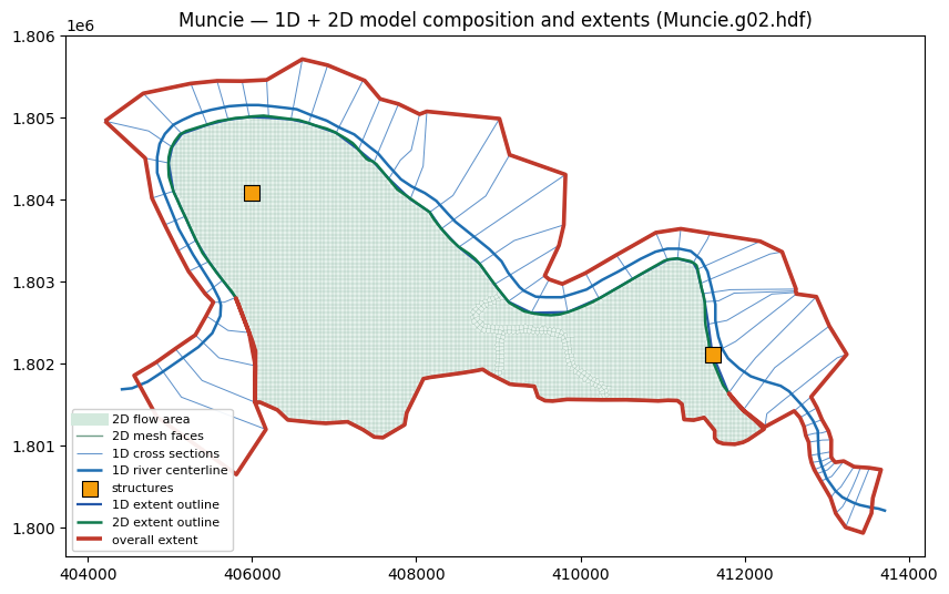
Muncie pairs a 2D flow area with a 1D river, cross sections, and inline structures in one geometry. The figure below layers the whole composition — 2D mesh area and faces, the 1D river and cross sections, and the structures — then draws the 1D, 2D, and overall extent outlines. Because the 1D and 2D domains overlap, combining their footprints leaves thin sliver gaps, which the new fill_holes option removes.
muncie = extract_or_reuse("Muncie", "extent_demo")
init_ras_project(muncie, "6.6")

muncie_geom = None
for candidate in find_geom_hdfs(muncie):
    if HdfMesh.get_mesh_area_names(candidate):
        muncie_geom = candidate
        break
print("Muncie 2D geometry:", muncie_geom.name)

# Model composition: the 2D mesh (area + faces) plus the 1D river, cross
# sections, and inline structures that share the same geometry.
muncie_mesh = HdfMesh.get_mesh_areas(muncie_geom)
muncie_faces = HdfMesh.get_mesh_cell_faces(muncie_geom)
muncie_river = HdfXsec.get_river_centerlines(muncie_geom)
muncie_xs = HdfXsec.get_cross_sections(muncie_geom)
muncie_struct = HdfStruc.get_structures(muncie_geom)

# 1D-only, 2D-only, and combined extents (fill_holes on by default).
muncie_1d, _ = HdfProject.get_project_extent(muncie_geom, include_2d=False, buffer_percent=0.0)
muncie_2d, _ = HdfProject.get_project_extent(muncie_geom, include_1d=False, buffer_percent=0.0)
muncie_full, _ = HdfProject.get_project_extent(muncie_geom, buffer_percent=0.0)
muncie_full_holes, _ = HdfProject.get_project_extent(
    muncie_geom, buffer_percent=0.0, fill_holes=False)

print("CRS:", muncie_mesh.crs.name if muncie_mesh.crs else None)
describe(muncie_mesh, "2D perimeter")
describe(muncie_faces, "2D mesh faces")
describe(muncie_xs, "1D cross sections")
describe(muncie_struct, "structures")
describe(muncie_full, "full footprint (1D + 2D)")

# Combining 1D and 2D leaves thin interior sliver gaps where the two boundaries
# overlap without aligning exactly. fill_holes=True (default) removes them.
holes_default = HdfProject._count_holes(muncie_full.geometry.iloc[0])
holes_kept = HdfProject._count_holes(muncie_full_holes.geometry.iloc[0])
print("interior holes  fill_holes=True:", holes_default, " fill_holes=False:", holes_kept)

assert not muncie_2d.empty and muncie_2d.geometry.is_valid.all()
assert holes_default == 0 and holes_kept > 0, "fill_holes should remove the slivers"
print("Checks passed.")
Muncie 2D geometry: Muncie.g02.hdf


CRS: NAD83 / Indiana East (ftUS)
  2D perimeter: rows=1 types=['Polygon'] area=13,709,793 valid=True
  2D mesh faces: rows=11164 types=['LineString'] area=0 valid=True
  1D cross sections: rows=61 types=['LineString'] area=0 valid=True
  structures: rows=2 types=['LineString'] area=0 valid=True
  full footprint (1D + 2D): rows=1 types=['Polygon'] area=25,580,805 valid=True
interior holes  fill_holes=True: 0  fill_holes=False: 12
Checks passed.
from matplotlib.lines import Line2D

fig, ax = plt.subplots(figsize=(10, 9))
# 2D mesh: filled area with the cell faces drawn on top.
muncie_mesh.plot(ax=ax, color="#d3e9dd", alpha=0.55, edgecolor="none", zorder=0)
muncie_faces.plot(ax=ax, color="#6f9e88", linewidth=0.25, alpha=0.75, zorder=1)
# 1D model: cross sections, river centerline, and inline structures.
muncie_xs.plot(ax=ax, color="#5b8fc9", linewidth=0.7, zorder=2, label="1D cross sections")
muncie_river.plot(ax=ax, color="#1f6fb2", linewidth=1.8, zorder=3, label="1D river centerline")
struct_pts = muncie_struct.geometry.centroid
ax.scatter(struct_pts.x, struct_pts.y, s=90, marker="s", facecolor="#f59e0b",
           edgecolor="black", linewidth=0.8, zorder=6, label="structures")
# Extents: 1D and 2D outlines in different colors, overall on top in a contrasting color.
muncie_1d.boundary.plot(ax=ax, color="#2457a8", linewidth=1.6, zorder=4, label="1D extent outline")
muncie_2d.boundary.plot(ax=ax, color="#0f7a4d", linewidth=1.8, zorder=4, label="2D extent outline")
muncie_full.boundary.plot(ax=ax, color="#c0392b", linewidth=2.6, zorder=5, label="overall extent")

# Add area/face swatches to the legend (plot() of fills/many lines does not auto-label).
handles, labels = ax.get_legend_handles_labels()
handles = [Line2D([0], [0], color="#d3e9dd", linewidth=8),
           Line2D([0], [0], color="#6f9e88", linewidth=1)] + handles
labels = ["2D flow area", "2D mesh faces"] + labels
ax.legend(handles, labels, loc="lower left", fontsize=8, framealpha=0.92)
ax.set_title(f"Muncie — 1D + 2D model composition and extents ({muncie_geom.name})")
ax.set_aspect("equal")
plt.show()
Removing 1D/2D sliver gaps (fill_holes)
Where the 1D reach footprint runs alongside the 2D flow area, the union of the two boundaries leaves thin interior sliver gaps — they are interior rings (holes) in the combined polygon, not real openings in the model. get_project_extent(..., fill_holes=True) (the default) drops those interior rings; the outer boundary and every genuinely separate part are untouched. Zoom in on the largest sliver to see it close.
import geopandas as gpd
from shapely.geometry import Polygon

g_holes = muncie_full_holes.geometry.iloc[0]
g_filled = muncie_full.geometry.iloc[0]
biggest = max(g_holes.interiors, key=lambda r: Polygon(r).area)
cx, cy = Polygon(biggest).centroid.x, Polygon(biggest).centroid.y
pad = 400

fig, axes = plt.subplots(1, 2, figsize=(12, 5.5))
for ax, g, ttl in [(axes[0], g_holes, "fill_holes=False (slivers remain)"),
                   (axes[1], g_filled, "fill_holes=True (default)")]:
    gpd.GeoSeries([g]).plot(ax=ax, color="#d3e9dd", edgecolor="#0f7a4d", linewidth=1.0)
    for ring in getattr(g, "interiors", []):
        gpd.GeoSeries([Polygon(ring)]).plot(ax=ax, color="#c0392b", alpha=0.75)
    ax.set_xlim(cx - pad, cx + pad); ax.set_ylim(cy - pad, cy + pad)
    ax.set_aspect("equal"); ax.set_title(ttl, fontsize=10)
fig.suptitle("Muncie — interior sliver gaps removed by fill_holes", fontsize=12)
plt.show()

assert HdfProject._count_holes(g_filled) == 0
assert g_filled.area >= g_holes.area  # filling holes only adds the gap area
print(f"Filled {len(g_holes.interiors)} interior sliver(s); "
      f"area change {100 * (g_filled.area - g_holes.area) / g_holes.area:.3f}%")
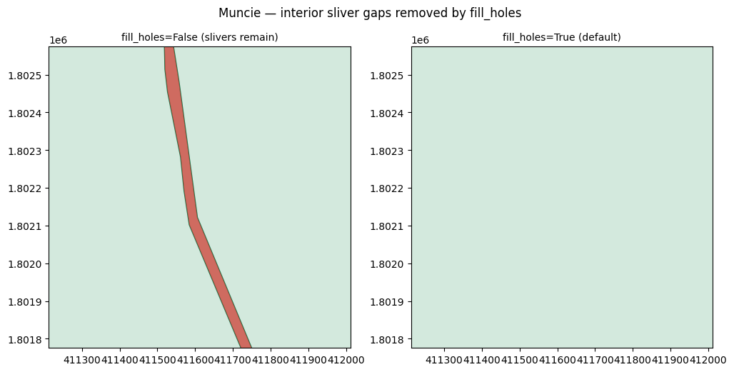
Filled 12 interior sliver(s); area change 0.221%
Authoring edge lines into the geometry HDF (no RASMapper GUI)
The edge_source='stored' path above needs a model that already carries
Geometry/River Edge Lines. This example ships without them, and ras-commander does not
write an approximation into the HDF: HEC-RAS stamps the layer with a Source Data Hash
over the cross-section geometry, and a hand-written layer that lacks a valid hash may be
silently recomputed. Edge lines that HEC-RAS honors come from HEC-RAS.
RasGeometryCompute.generate_edge_lines() runs its real bank-line-anchored offset-curve
algorithm in-process via pythonnet (RasMapperLib) -- no GUI, no subprocess. It mutates
the geometry HDF in place, so we run it on a disposable copy and skip cleanly when HEC-RAS
is unavailable. See 234_rasmapper_geometry_completion.ipynb for the full picture
(interpolation surface, flow paths, validation diagnostics, reach-length auditing); on
Linux, RasProcess.compute_geometry() is the RasProcess.exe + Wine equivalent.
import h5py

from ras_commander import RasPrj, RasGeometryCompute
from ras_commander.dotnet.clr_bootstrap import is_hecras_available

if not is_hecras_available():
    print("HEC-RAS / pythonnet not available - skipping headless edge-line authoring.")
else:
    # Fresh copy so the examples above are untouched.
    author_project = extract_or_reuse("BaldEagleCrkMulti2D", "edge_author")
    author_ras = RasPrj()
    init_ras_project(author_project, "6.6", ras_object=author_ras)
    author_geom = None
    for candidate in find_geom_hdfs(author_project):
        xs = HdfXsec.get_cross_sections(candidate, ras_object=author_ras)
        if xs is not None and not xs.empty:
            author_geom = candidate
            break
    print("Authoring into:", author_geom.name)

    before = HdfXsec.get_river_edge_lines(author_geom)
    print("stored edge lines before:", 0 if before is None or before.empty else len(before))

    result = RasGeometryCompute.generate_edge_lines(author_geom, ras_object=author_ras)
    print(f"generate_edge_lines: success={result.success} elapsed={result.elapsed_seconds:.1f}s")

    # HEC-RAS-authored: no Attributes dataset, and a group-level Source Data Hash.
    # Bank side is derived from row order (Left, Right per reach), as HEC-RAS does.
    genuine = HdfXsec.get_river_edge_lines(author_geom)
    describe(genuine, "stored edge lines after")
    print("bank sides:", list(genuine["bank_side"]))

    # The stored-source footprint now works.
    fp_stored = HdfXsec.get_1d_footprint(author_geom, edge_source="stored", ras_object=author_ras)
    describe(fp_stored, "footprint (edge_source='stored')")

    with h5py.File(author_geom, "r") as f:
        grp = f["Geometry/River Edge Lines"]
        assert "Source Data Hash" in grp.attrs, "HEC-RAS stamps the layer with its hash"
        assert "Attributes" not in grp, "HEC-RAS writes no Attributes for this layer"

    assert result.success and not genuine.empty
    assert list(genuine["bank_side"]) == ["Left" if i % 2 == 0 else "Right"
                                          for i in range(len(genuine))]
    assert set(fp_stored["source"]) == {"stored_edge_lines"}
    print("")
    print("Checks passed: HEC-RAS authored real edge lines headlessly, "
          "and they drive the stored footprint path.")
Authoring into: BaldEagleDamBrk.g06.hdf
stored edge lines before: 2
generate_edge_lines: success=True elapsed=0.0s
  stored edge lines after: rows=2 types=['LineString'] area=0 valid=True
bank sides: ['Left', 'Right']
  footprint (edge_source='stored'): rows=1 types=['Polygon'] area=710,952,219 valid=True

Checks passed: HEC-RAS authored real edge lines headlessly, and they drive the stored footprint path.
Key takeaways
HdfProject.get_project_extent(geometry_type='footprint')returns the true model extent polygon (1D reach footprints + 2D perimeters), replacing the old bounding-box-only behavior. Usegeometry_type='bbox'for the legacy buffered box (still used internally for precipitation/terrain download windows).include_1d/include_2dslice the extent into 1D-only or 2D-only footprints; multiple areas or reaches produce a multipart polygon.HdfXsec.get_1d_footprint()builds the 1D corridor from river edge lines, andHdfXsec.generate_river_edge_lines()derives those edge lines from cross-section end points when the model has none stored.- The reach ring is closed on the end cross sections' real cut-line geometry, so bent
cut lines are preserved.
close_with_end_xs=Falserestores the straight-chord closure. RasGeometryCompute.generate_edge_lines()authors HEC-RAS's own edge lines into the geometry HDF in-process (pythonnet, no GUI), which is what makesedge_source='stored'usable on a model that shipped without them. ras-commander deliberately has no pure-Python writer for this layer -- only HEC-RAS can stamp theSource Data Hash.fill_holes=True(the new default ofget_project_extent) removes the thin interior sliver gaps left where 1D reach footprints and 2D flow areas overlap. Only interior rings are dropped — disconnected parts of a multipart model are preserved. Passfill_holes=Falseto keep the raw union.- Pass
buffer_percent=0for the raw footprint; a positive value buffers it outward.