NextGen Hydrofabric Conflation Visual QA — Texas eBFE Shiloh Branch
This notebook performs a real-data visual review of
RasNetworkConflation.conflate() using the Lower Colorado–Cummins Texas
eBFE/BLE delivery (HUC8 12090301) and its 1D SHILOH BRANCH reach. It
compares the HEC-RAS footprint, river centerline, and 40 cross sections with
native NextGen v2.2 flowpaths and catchments, then exposes every score
component used to resolve the match.
What you will verify
- Model footprint, centerline, XS cut lines, flowpaths, and HUC12 boundaries align in one projected CRS.
- Candidate rank reflects overlap, distance, direction, XS intersections, topology, stream scale, and sequence evidence.
- Accepted links retain
feature_id, confidence, reasons, and measures. - A deliberately strict sensitivity run exposes
matched,ambiguous, andunmatchedstates without fake accepted COMIDs.
The model is obtained through RasEbfeModels. The network is the public
CIROH NextGen v2.2 VPU 12 geopackage,
used by the NextGen Research Datastream.
HUC12 reporting polygons come independently from the
USGS Watershed Boundary Dataset.
The thresholds here are visual-QA parameters, not ras2fim or production acceptance policy. The strict run is intentionally conservative.
# =============================================================================
# DEVELOPMENT MODE TOGGLE
# =============================================================================
USE_LOCAL_SOURCE = True

import logging
import os
import sys
from pathlib import Path
from xml.etree import ElementTree as ET
from zipfile import ZipFile

if USE_LOCAL_SOURCE:
    here = Path.cwd().resolve()
    repo_root = next(
        (p for p in [here, *here.parents] if (p / "ras_commander" / "__init__.py").exists()),
        here,
    )
    sys.path.insert(0, str(repo_root))
    print("LOCAL SOURCE MODE:", repo_root.name)
else:
    repo_root = Path.cwd().resolve()
    print("PIP PACKAGE MODE")

import geopandas as gpd
import matplotlib.pyplot as plt
import numpy as np
import pandas as pd
import requests
from matplotlib.lines import Line2D
from matplotlib.patches import Patch
from pyproj import CRS

import ras_commander
from ras_commander import (
    HdfProject,
    HdfXsec,
    RasCmdr,
    RasNetworkConflation,
    RasPlan,
    init_ras_project,
)
from ras_commander.sources.federal import RasEbfeModels

logging.getLogger("ras_commander").setLevel(logging.ERROR)
plt.rcParams.update({"figure.dpi": 120, "axes.titlesize": 12})
working_dir = repo_root / "working" / "example_956_hydrofabric_conflation"
working_dir.mkdir(parents=True, exist_ok=True)
print("ras-commander source:", Path(ras_commander.__file__).name)
print("Working cache:", working_dir.relative_to(repo_root))
LOCAL SOURCE MODE: hydrofabric-hardening


ras-commander source: __init__.py
Working cache: working\example_956_hydrofabric_conflation
1. Reuse or organize the Texas eBFE model
Lower Colorado–Cummins is a Texas 1D steady BLE reach collection. SHILOH BRANCH is compact enough for legible maps while providing 40 independent XS checks. The organizer downloads the archive only when it is absent.
BLE_RIVER = "Rabbs Creek-Colorado River"
BLE_REACH_NAME = "SHILOH BRANCH"
RAS_VERSION = "7.0"
EBFE_WORKSPACE = Path(os.environ.get(
    "RAS_COMMANDER_EBFE_ROOT", working_dir / "ebfe_workspace"
))
DOWNLOAD_ROOT = EBFE_WORKSPACE / "Downloads"
ORGANIZED_ROOT = EBFE_WORKSPACE / "Organized"
organized = ORGANIZED_ROOT / "LowerColoradoCummins_12090301"
project_folder = organized / "RAS Model" / BLE_RIVER / BLE_REACH_NAME

if not (project_folder / f"{BLE_REACH_NAME}.prj").exists():
    organized = RasEbfeModels.organize_model(
        "lower-colorado-cummins", download_root=DOWNLOAD_ROOT,
        output_root=ORGANIZED_ROOT, river=BLE_RIVER, reach=BLE_REACH_NAME,
    )
    project_folder = organized / "RAS Model" / BLE_RIVER / BLE_REACH_NAME

print("Organized study:", organized.name)
print("Project:", Path("RAS Model") / BLE_RIVER / BLE_REACH_NAME)
Organized study: LowerColoradoCummins_12090301
Project: RAS Model\Rabbs Creek-Colorado River\SHILOH BRANCH
The original BLE project predates geometry-HDF output. A migrated HDF is reused when present. On a fresh Windows workspace, ras-commander enables the necessary run flags and computes the steady plan with HEC-RAS 7.0.
GENERATE_HDF_IF_MISSING = True
ras = init_ras_project(project_folder, RAS_VERSION)
geom_hdf = project_folder / f"{ras.project_name}.g01.hdf"
if not geom_hdf.exists():
    if not GENERATE_HDF_IF_MISSING:
        raise FileNotFoundError(f"Set GENERATE_HDF_IF_MISSING=True to create {geom_hdf.name}")
    RasPlan.update_run_flags(
        "01", geometry_preprocessor=True, post_processor=True, ras_object=ras
    )
    RasCmdr.compute_plan("01", ras_object=ras, force_geompre=True)
    ras = init_ras_project(project_folder, RAS_VERSION)
if not geom_hdf.exists():
    raise FileNotFoundError(f"HEC-RAS did not create {geom_hdf}")
print("Geometry HDF:", geom_hdf.name, f"({geom_hdf.stat().st_size:,} bytes)")
Geometry HDF: SHILOH BRANCH.g01.hdf (332,579 bytes)
2. Extract and identify HEC-RAS geometry
This legacy delivery stores its authoritative projection WKT in the vendor
XML rather than the HDF. We recover EPSG:2277 (NAD83 / Texas Central ftUS),
assign it to the public HDF-reader outputs, and add stable IDs.
project_xml = project_folder / f"{ras.project_name}.xml"
projection_wkt = (ET.parse(project_xml).findtext("Projection") or "").strip()
model_crs = CRS.from_wkt(projection_wkt)
cross_sections = HdfXsec.get_cross_sections(geom_hdf).set_crs(model_crs, allow_override=True)
centerlines = HdfXsec.get_river_centerlines(geom_hdf).set_crs(model_crs, allow_override=True)
model_footprints, _ = HdfProject.get_project_extent(
    geom_hdf, geometry_type="footprint", include_2d=False, buffer_percent=0.0
)
model_footprints = model_footprints.set_crs(model_crs, allow_override=True)

geometry_id = "lower-colorado-cummins-shiloh-branch"
model_footprints["geometry_id"] = geometry_id
centerlines["geometry_id"] = geometry_id
centerlines["reach_id"] = (
    centerlines["River Name"].astype(str).str.strip() + " / "
    + centerlines["Reach Name"].astype(str).str.strip()
)
cross_sections["geometry_id"] = geometry_id
cross_sections["reach_id"] = (
    cross_sections["River"].astype(str).str.strip() + " / "
    + cross_sections["Reach"].astype(str).str.strip()
)
cross_sections["xs_id"] = cross_sections["RS"].astype(str).str.strip()

model_summary = pd.DataFrame({
    "layer": ["model footprint", "river centerline", "cross sections"],
    "features": [len(model_footprints), len(centerlines), len(cross_sections)],
    "geometry_type": [", ".join(sorted(set(g.geom_type)))
                      for g in (model_footprints, centerlines, cross_sections)],
})
print("Model CRS:", model_crs.to_authority(), "—", model_crs.name)
display(model_summary)
Model CRS: ('EPSG', '2277') — NAD83 / Texas Central (ftUS)
| layer | features | geometry_type | |
|---|---|---|---|
| 0 | model footprint | 1 | Polygon |
| 1 | river centerline | 1 | LineString |
| 2 | cross sections | 40 | LineString |
3. Load NextGen v2.2 flowpaths, catchments, and HUC12 polygons
VPU 12 is downloaded once and cached under
working/example_956_hydrofabric_conflation/. Only flowpaths and divides
within 1,500 m of the HEC-RAS footprint are read into memory. The native
NextGen identifiers (wb-*, cat-*, and nex-*) are preserved. HUC12s are
a separate reporting layer read from the USGS HUC8 data archive.
A cold run downloads about 215 MiB (191 MiB NextGen plus 23 MiB WBD) and may also organize or compute the eBFE model. A warm-cache review normally completes in about five minutes.
NEXTGEN_URL = (
    "https://ciroh-community-ngen-datastream.s3.amazonaws.com/"
    "resources/v2.2_hydrofabric/geopackages/VPU_12/nextgen_VPU_12.gpkg"
)
WBD_HU8_URL = (
    "https://prd-tnm.s3.amazonaws.com/StagedProducts/Hydrography/NHD/HU8/"
    "GPKG/NHD_H_12090301_HU8_GPKG.zip"
)
REFRESH_SOURCES = False
NEXTGEN_EXPECTED_BYTES = 200_265_728
WBD_ARCHIVE_EXPECTED_BYTES = 24_513_660
WBD_GPKG_EXPECTED_BYTES = 73_084_928
nextgen_cache = working_dir / "nextgen_VPU_12_v2.2.gpkg"
wbd_archive = working_dir / "NHD_H_12090301_HU8_GPKG.zip"
wbd_cache = working_dir / "NHD_H_12090301_HU8_GPKG.gpkg"

def cache_has_expected_size(path, expected_bytes):
    return path.exists() and path.stat().st_size == expected_bytes

def download_file(url, destination, expected_bytes):
    partial = destination.with_name(f"{destination.name}.part")
    if partial.exists():
        partial.unlink()
    with requests.get(url, stream=True, timeout=120) as response:
        response.raise_for_status()
        with partial.open("wb") as stream:
            for chunk in response.iter_content(chunk_size=1024 * 1024):
                if chunk:
                    stream.write(chunk)
    actual_bytes = partial.stat().st_size
    if actual_bytes != expected_bytes:
        partial.unlink()
        raise OSError(
            f"Unexpected download size for {destination.name}: "
            f"{actual_bytes:,} bytes (expected {expected_bytes:,})"
        )
    partial.replace(destination)

if REFRESH_SOURCES or not cache_has_expected_size(
    nextgen_cache, NEXTGEN_EXPECTED_BYTES
):
    download_file(NEXTGEN_URL, nextgen_cache, NEXTGEN_EXPECTED_BYTES)
    nextgen_state = "downloaded and cached"
else:
    nextgen_state = "loaded from working cache"

if REFRESH_SOURCES or not cache_has_expected_size(
    wbd_cache, WBD_GPKG_EXPECTED_BYTES
):
    if REFRESH_SOURCES or not cache_has_expected_size(
        wbd_archive, WBD_ARCHIVE_EXPECTED_BYTES
    ):
        download_file(
            WBD_HU8_URL, wbd_archive, WBD_ARCHIVE_EXPECTED_BYTES
        )
    with ZipFile(wbd_archive) as archive:
        gpkg_members = [
            member for member in archive.namelist()
            if Path(member).suffix.lower() == ".gpkg"
        ]
        if len(gpkg_members) != 1:
            raise OSError(
                f"Expected one GPKG in {wbd_archive.name}; "
                f"found {len(gpkg_members)}"
            )
        extracted = Path(archive.extract(gpkg_members[0], working_dir))
    if extracted != wbd_cache:
        extracted.replace(wbd_cache)
    if not cache_has_expected_size(wbd_cache, WBD_GPKG_EXPECTED_BYTES):
        raise OSError(f"Unexpected extracted size for {wbd_cache.name}")
    wbd_state = "downloaded and cached"
else:
    wbd_state = "loaded from working cache"

query_bounds_5070 = model_footprints.to_crs(5070).buffer(1500).total_bounds
flowpaths = gpd.read_file(
    nextgen_cache, layer="flowpaths", bbox=tuple(query_bounds_5070)
)
divides = gpd.read_file(
    nextgen_cache, layer="divides", bbox=tuple(query_bounds_5070)
)

query_bounds_4269 = model_footprints.to_crs(5070).buffer(1500).to_crs(4269).total_bounds
hucs = gpd.read_file(
    wbd_cache, layer="WBDHU12", bbox=tuple(query_bounds_4269)
)
flowpaths = flowpaths.loc[flowpaths.geometry.notna() & ~flowpaths.geometry.is_empty].copy()
divides = divides.loc[divides.geometry.notna() & ~divides.geometry.is_empty].copy()
hucs = hucs.loc[hucs.geometry.notna() & ~hucs.geometry.is_empty].copy()
print(f"NextGen v2.2 VPU 12 flowpaths: {len(flowpaths)} ({nextgen_state})")
print(f"NextGen catchments: {len(divides)}")
print(f"WBD HUC12 polygons: {len(hucs)} ({wbd_state})")
display(flowpaths[[
    "id", "toid", "order", "hydroseq", "areasqkm",
    "tot_drainage_areasqkm", "divide_id",
]].sort_values("hydroseq").reset_index(drop=True))
display(hucs[["huc12", "name"]].sort_values("huc12").reset_index(drop=True))
NextGen v2.2 VPU 12 flowpaths: 9 (loaded from working cache)
NextGen catchments: 12
WBD HUC12 polygons: 3 (loaded from working cache)
| id | toid | order | hydroseq | areasqkm | tot_drainage_areasqkm | divide_id | |
|---|---|---|---|---|---|---|---|
| 0 | wb-2430631 | nex-2430632 | 6.0 | 12023 | 11.194199 | 94312.085537 | cat-2430631 |
| 1 | wb-2430630 | nex-2430631 | 6.0 | 12024 | 26.901002 | 94277.320338 | cat-2430630 |
| 2 | wb-2430628 | nex-2430629 | 6.0 | 12027 | 10.705950 | 94229.803038 | cat-2430628 |
| 3 | wb-2437147 | nex-2437142 | 3.0 | 12056 | 11.803050 | 99.387451 | cat-2437147 |
| 4 | wb-2430904 | nex-2430902 | 1.0 | 18551 | 11.745899 | 16.536600 | cat-2430904 |
| 5 | wb-2430903 | nex-2430904 | 1.0 | 18552 | 4.790700 | 4.790700 | cat-2430903 |
| 6 | wb-2430902 | nex-2430631 | 1.0 | 18553 | 7.034400 | 7.034400 | cat-2430902 |
| 7 | wb-2437184 | nex-2430632 | 1.0 | 18555 | 9.503551 | 9.503551 | cat-2437184 |
| 8 | wb-2437189 | nex-2437190 | 1.0 | 18586 | 10.539451 | 10.539451 | cat-2437189 |
| huc12 | name | |
|---|---|---|
| 0 | 120903010503 | Little Pin Oak Creek |
| 1 | 120903010506 | Lower Rabbs Creek |
| 2 | 120903010507 | Cedar Creek-Colorado River |
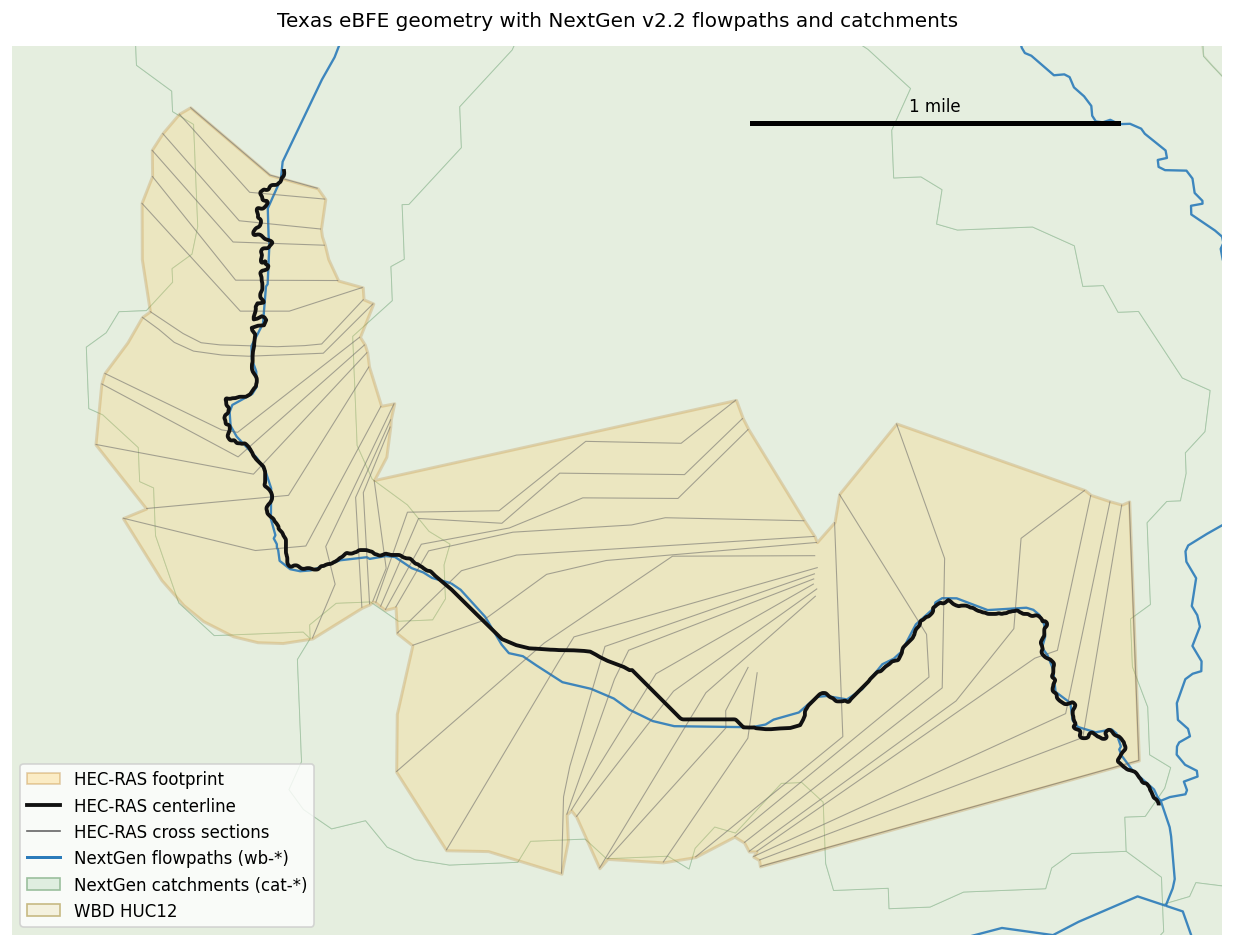
Source-data alignment map
First verify that the model and hydrofabric occupy the same corridor. The blue network and green catchments are the native NextGen layers; black and gray are HEC-RAS geometry. The tan HUC12 boundary is reporting context only.
flowpaths_model = flowpaths.to_crs(model_crs)
divides_model = divides.to_crs(model_crs)
hucs_model = hucs.to_crs(model_crs)
fig, ax = plt.subplots(figsize=(11, 8))
hucs_model.plot(ax=ax, color="#f4f1de", edgecolor="#c7b983", linewidth=1)
divides_model.plot(ax=ax, color="#dfeee0", edgecolor="#9bbf9d", linewidth=.55, alpha=.7)
flowpaths_model.plot(ax=ax, color="#2b7bba", linewidth=1.4, alpha=.9)
model_footprints.plot(ax=ax, color="#ffd166", edgecolor="#b7791f", lw=1.8, alpha=.25)
cross_sections.plot(ax=ax, color="#666666", linewidth=.65, alpha=.55)
centerlines.plot(ax=ax, color="#111111", linewidth=2.3)
xmin, ymin, xmax, ymax = model_footprints.total_bounds
xp, yp = (xmax-xmin)*.08, (ymax-ymin)*.08
ax.set(xlim=(xmin-xp, xmax+xp), ylim=(ymin-yp, ymax+yp), aspect="equal")
sx, sy = xmax-5280-xp*.25, ymax-yp*.25
ax.plot([sx, sx+5280], [sy, sy], color="black", lw=3)
ax.text(sx+2640, sy+yp*.12, "1 mile", ha="center", va="bottom")
ax.set_axis_off()
ax.set_title("Texas eBFE geometry with NextGen v2.2 flowpaths and catchments", pad=12)
ax.legend(handles=[
    Patch(facecolor="#ffd166", edgecolor="#b7791f", alpha=.35, label="HEC-RAS footprint"),
    Line2D([0],[0], color="#111111", lw=2.3, label="HEC-RAS centerline"),
    Line2D([0],[0], color="#666666", lw=1, label="HEC-RAS cross sections"),
    Line2D([0],[0], color="#2b7bba", lw=1.8, label="NextGen flowpaths (wb-*)"),
    Patch(facecolor="#dfeee0", edgecolor="#9bbf9d", label="NextGen catchments (cat-*)"),
    Patch(facecolor="#f4f1de", edgecolor="#c7b983", label="WBD HUC12"),
], loc="lower left")
plt.tight_layout()
plt.show()
4. Run multi-criteria conflation
The NextGen adapter preserves wb-* feature IDs and normalizes the nex-*
downstream link, stream order, drainage area, and hydrosequence. HUC
intersections are reporting evidence and do not influence the candidate score.
result = RasNetworkConflation.conflate(
    model_footprints, centerlines, cross_sections, flowpaths,
    adapter="nextgen", hucs=hucs, huc_id_col="huc12",
    max_candidates=8, min_confidence=.55, ambiguity_margin=.05,
)
status_order = ["matched", "ambiguous", "unmatched"]
status_by_element = pd.crosstab(result.matches.element_type, result.matches.status)
status_by_element = status_by_element.reindex(columns=status_order, fill_value=0)
status_by_element["total"] = status_by_element.sum(axis=1)
print("Adapter:", result.adapter, "| Analysis CRS:", result.analysis_crs)
print("Parameters:", result.parameters)
display(status_by_element)

reach_match = result.matches.loc[result.matches.element_type == "reach"].iloc[0]
reach_candidates = result.candidates.loc[
    result.candidates.element_type == "reach"
].sort_values("candidate_rank").copy()
print(f"Accepted reach feature: {reach_match.feature_id}; "
      f"confidence={reach_match.confidence_score:.3f}; margin={reach_match.score_margin:.3f}")
display(reach_candidates[[
    "candidate_rank", "feature_id", "confidence_score", "centerline_mean_distance",
    "angular_difference_deg", "xs_intersection_count", "xs_total_count",
    "stream_order", "drainage_area", "reason_codes",
]].reset_index(drop=True))
Adapter: nextgen | Analysis CRS: EPSG:2277
Parameters: {'weights': {'footprint_overlap': 0.15, 'centerline_distance': 0.2, 'direction_agreement': 0.12, 'xs_intersections': 0.18, 'topological_continuity': 0.15, 'stream_order_drainage_area': 0.1, 'sequence_consistency': 0.1}, 'search_distance': 6322.941270214319, 'topology_tolerance': 505.83530161714555, 'max_candidates': 8, 'min_confidence': 0.55, 'ambiguity_margin': 0.05, 'min_coverage': 0.5, 'sample_count': 9}
| status | matched | ambiguous | unmatched | total |
|---|---|---|---|---|
| element_type | ||||
| cross_section | 40 | 0 | 0 | 40 |
| geometry | 1 | 0 | 0 | 1 |
| reach | 1 | 0 | 0 | 1 |
Accepted reach feature: wb-2430904; confidence=0.702; margin=0.144
| candidate_rank | feature_id | confidence_score | centerline_mean_distance | angular_difference_deg | xs_intersection_count | xs_total_count | stream_order | drainage_area | reason_codes | |
|---|---|---|---|---|---|---|---|---|---|---|
| 0 | 1 | wb-2430904 | 0.702497 | 942.425123 | 20.638119 | 18 | 40 | 1.0 | 16.536600 | (FOOTPRINT_OVERLAP_STRONG, DIRECTION_ALIGNED, ... |
| 1 | 2 | wb-2430903 | 0.558744 | 2398.982525 | 62.216023 | 22 | 40 | 1.0 | 4.790700 | (FOOTPRINT_OVERLAP_PARTIAL, XS_INTERSECTIONS_S... |
| 2 | 3 | wb-2430630 | 0.315272 | 6475.097206 | 61.854127 | 0 | 40 | 6.0 | 94277.320338 | (HYDROLOGIC_SCALE_SUPPORTED,) |
| 3 | 4 | wb-2430631 | 0.299312 | 8989.302952 | 28.280671 | 0 | 40 | 6.0 | 94312.085537 | (DIRECTION_ALIGNED, HYDROLOGIC_SCALE_SUPPORTED) |
| 4 | 5 | wb-2430902 | 0.281819 | 6098.493153 | 37.340342 | 0 | 40 | 1.0 | 7.034400 | (DIRECTION_ALIGNED, SEQUENCE_CONSISTENT) |
| 5 | 6 | wb-2437184 | 0.230474 | 10004.162288 | 3.082776 | 0 | 40 | 1.0 | 9.503551 | (DIRECTION_ALIGNED,) |
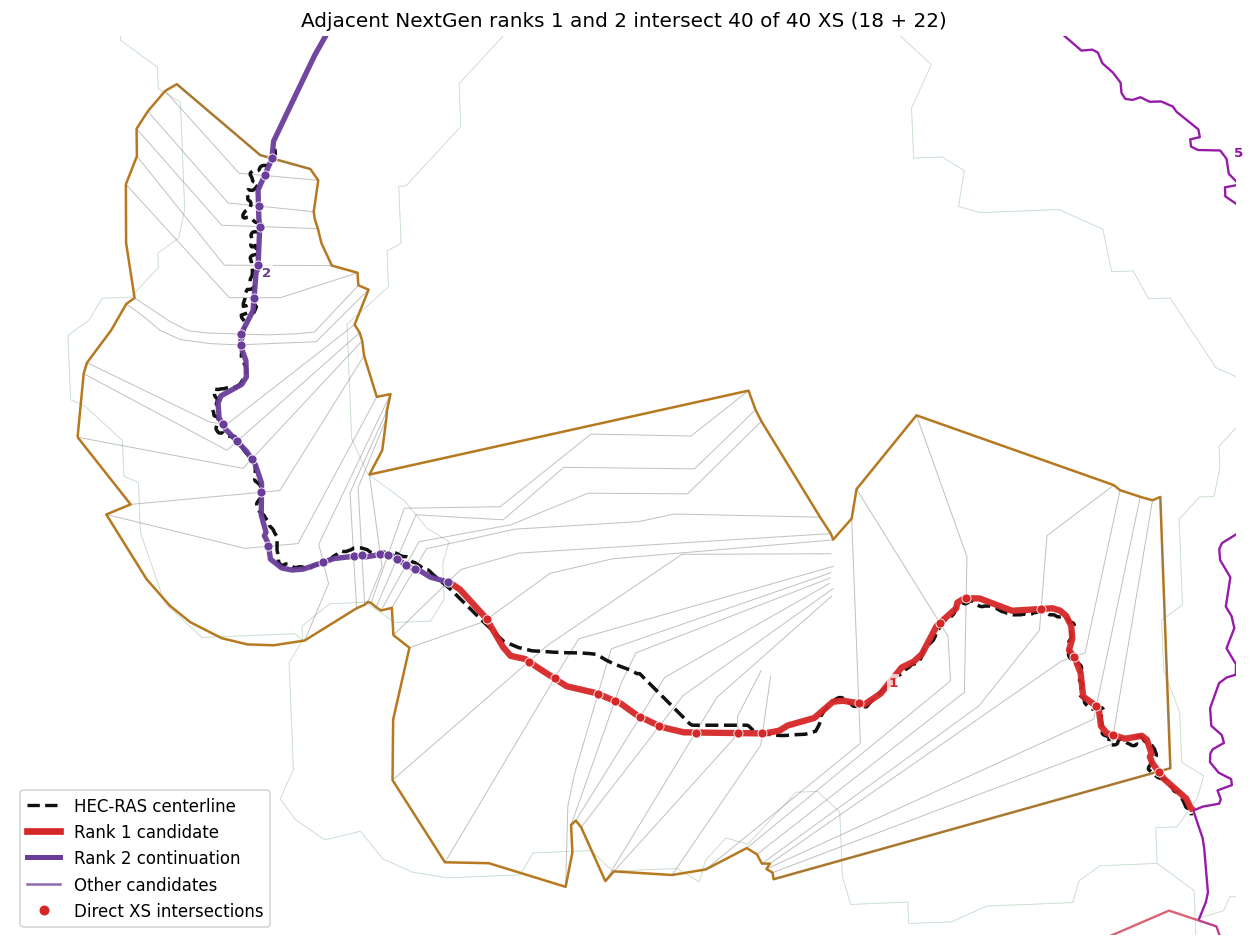
Candidate map and direct XS evidence
Red and purple points mark exact XS intersections with the two adjacent leading candidates. Together they show why a single HEC-RAS reach can map to a sequence of shorter NextGen flowpaths. Ranks 3–8 remain visible for review.
fig, ax = plt.subplots(figsize=(12, 8))
divides_model.boundary.plot(ax=ax, color="#bdd7bf", linewidth=.45, alpha=.6)
flowpaths_model.plot(ax=ax, color="#d8e8f0", linewidth=.8, alpha=.8)
model_footprints.boundary.plot(ax=ax, color="#b7791f", linewidth=1.5)
cross_sections.plot(ax=ax, color="#777777", linewidth=.6, alpha=.45)
centerlines.plot(ax=ax, color="#111111", linewidth=2.1, linestyle="--")
colors = plt.cm.plasma_r(np.linspace(.18, .82, len(reach_candidates)))
for color, (_, candidate) in zip(colors[::-1], reach_candidates.iloc[::-1].iterrows()):
    rank = int(candidate.candidate_rank)
    if rank == 1:
        line_color, width = "#d62728", 3.8
    elif rank == 2:
        line_color, width = "#6a3d9a", 3.2
    else:
        line_color, width = color, 1.4
    gpd.GeoSeries([candidate.geometry], crs=result.analysis_crs).plot(
        ax=ax, color=line_color, linewidth=width, alpha=.95
    )
    midpoint = candidate.geometry.interpolate(.5, normalized=True)
    ax.annotate(str(rank), (midpoint.x, midpoint.y), xytext=(4,4),
                textcoords="offset points", fontsize=8, weight="bold", color=line_color,
                bbox={"facecolor":"white", "edgecolor":"none", "alpha":.75, "pad":1})
top_two_counts = []
for rank, point_color in [(1, "#d62728"), (2, "#6a3d9a")]:
    candidate_geometry = reach_candidates.iloc[rank - 1].geometry
    xs_intersection_count = int(
        cross_sections.geometry.intersects(candidate_geometry).sum()
    )
    intersections = cross_sections.geometry.intersection(candidate_geometry)
    points = gpd.GeoDataFrame(
        geometry=intersections.loc[~intersections.is_empty], crs=model_crs
    ).explode(index_parts=False)
    points = points.loc[points.geom_type.isin(["Point", "MultiPoint"])]
    top_two_counts.append(xs_intersection_count)
    points.plot(
        ax=ax, color=point_color, edgecolor="white", linewidth=.5,
        markersize=30, zorder=8,
    )
xmin, ymin, xmax, ymax = model_footprints.total_bounds
xp, yp = (xmax-xmin)*.06, (ymax-ymin)*.06
ax.set(xlim=(xmin-xp,xmax+xp), ylim=(ymin-yp,ymax+yp), aspect="equal")
ax.set_axis_off()
ax.set_title(
    f"Adjacent NextGen ranks 1 and 2 intersect {sum(top_two_counts)} of "
    f"{int(reach_candidates.iloc[0].xs_total_count)} XS "
    f"({top_two_counts[0]} + {top_two_counts[1]})"
)
ax.legend(handles=[
    Line2D([0],[0], color="#111111", lw=2, ls="--", label="HEC-RAS centerline"),
    Line2D([0],[0], color="#d62728", lw=4, label="Rank 1 candidate"),
    Line2D([0],[0], color="#6a3d9a", lw=3, label="Rank 2 continuation"),
    Line2D([0],[0], color="#8c6bb1", lw=1.5, label="Other candidates"),
    Line2D([0],[0], marker="o", color="none", markerfacecolor="#d62728",
           markeredgecolor="white", markersize=7, label="Direct XS intersections"),
], loc="lower left")
plt.tight_layout()
plt.show()
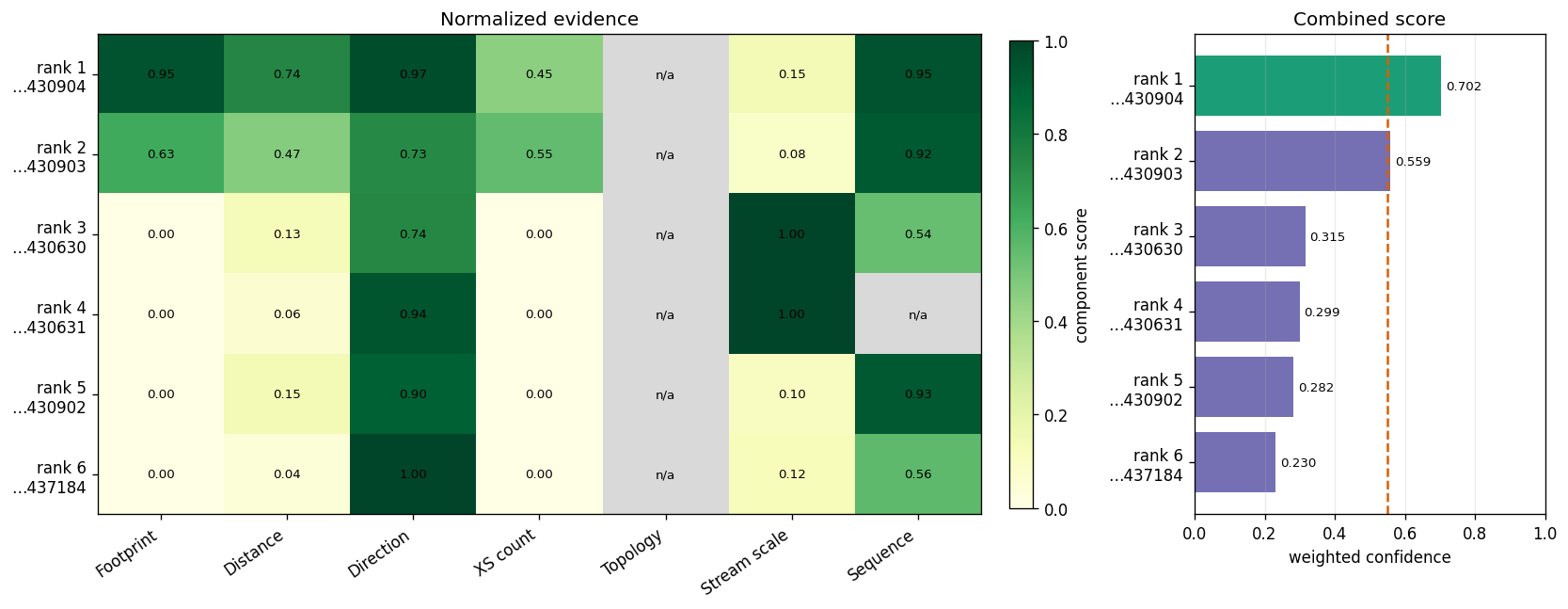
Score-component audit
Gray means evidence unavailable and its weight was renormalized away. A one-reach model has no model-to-model topology neighbor, so that column is n/a.
score_columns = [
    "footprint_overlap_score", "centerline_distance_score",
    "direction_agreement_score", "xs_intersection_score",
    "topological_continuity_score", "hydrologic_score",
    "sequence_consistency_score",
]
labels = ["Footprint","Distance","Direction","XS count","Topology","Stream scale","Sequence"]
view = reach_candidates.head(6)
matrix = view[score_columns].to_numpy(dtype=float)
ylabels = [f"rank {int(r)}\n…{str(fid)[-6:]}" for r,fid in zip(view.candidate_rank,view.feature_id)]
fig, (heat, total) = plt.subplots(1,2,figsize=(14,5.5),gridspec_kw={"width_ratios":[3.2,1.2]})
cmap = plt.cm.YlGn.copy()
cmap.set_bad("#d9d9d9")
image = heat.imshow(np.ma.masked_invalid(matrix), vmin=0, vmax=1, cmap=cmap, aspect="auto")
for i in range(matrix.shape[0]):
    for j in range(matrix.shape[1]):
        heat.text(j,i,"n/a" if np.isnan(matrix[i,j]) else f"{matrix[i,j]:.2f}",
                  ha="center",va="center",fontsize=8)
heat.set_xticks(range(len(labels)),labels,rotation=35,ha="right")
heat.set_yticks(range(len(ylabels)),ylabels)
heat.set_title("Normalized evidence")
fig.colorbar(image,ax=heat,fraction=.025,pad=.03,label="component score")
totals=view.confidence_score.to_numpy()
bars=total.barh(range(len(totals)),totals,color=["#1b9e77"]+["#7570b3"]*(len(totals)-1))
total.axvline(result.parameters["min_confidence"],color="#d95f02",ls="--",lw=1.5)
total.set_yticks(range(len(ylabels)),ylabels)
total.invert_yaxis()
total.set_xlim(0,1)
total.set_xlabel("weighted confidence")
total.set_title("Combined score")
total.bar_label(bars,labels=[f"{v:.3f}" for v in totals],padding=3,fontsize=8)
total.grid(axis="x",alpha=.25)
plt.tight_layout()
plt.show()
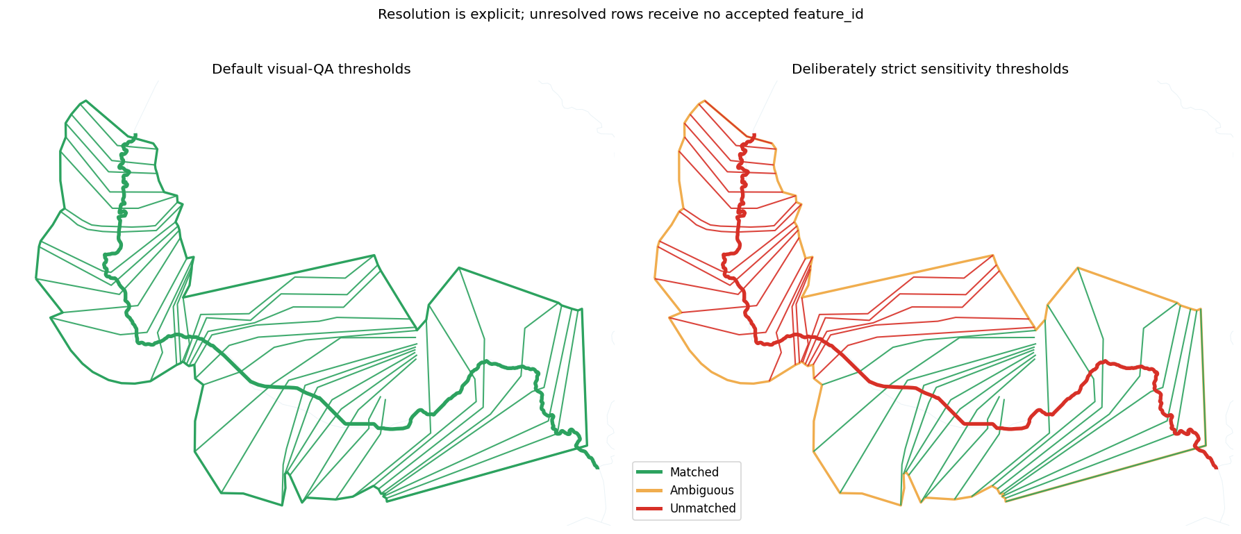
5. Inspect explicit ambiguous and unmatched states
The same evidence is re-resolved with min_confidence=0.75 and
ambiguity_margin=0.25. Best candidates remain reviewable, but accepted
feature_id is null for every unresolved row.
strict_result = RasNetworkConflation.conflate(
    model_footprints, centerlines, cross_sections, flowpaths,
    adapter="nextgen", hucs=hucs, huc_id_col="huc12",
    max_candidates=8, min_confidence=.75, ambiguity_margin=.25,
)
strict_status = pd.crosstab(strict_result.matches.element_type, strict_result.matches.status)
strict_status = strict_status.reindex(columns=status_order, fill_value=0)
strict_status["total"] = strict_status.sum(axis=1)
unresolved = strict_result.matches.loc[strict_result.matches.status != "matched"]
assert unresolved.feature_id.isna().all()
display(strict_status)
display(unresolved[[
    "element_type","reach_id","xs_id","feature_id","best_candidate_feature_id",
    "status","confidence_score","score_margin","match_method","reason_codes",
]].head(12))
| status | matched | ambiguous | unmatched | total |
|---|---|---|---|---|
| element_type | ||||
| cross_section | 18 | 0 | 22 | 40 |
| geometry | 0 | 1 | 0 | 1 |
| reach | 0 | 0 | 1 | 1 |
| element_type | reach_id | xs_id | feature_id | best_candidate_feature_id | status | confidence_score | score_margin | match_method | reason_codes | |
|---|---|---|---|---|---|---|---|---|---|---|
| 0 | geometry | NaN | NaN | NaN | wb-2430904 | ambiguous | 0.791748 | 0.100627 | multi_criteria_ambiguous | (FOOTPRINT_OVERLAP_STRONG, DIRECTION_ALIGNED, ... |
| 1 | reach | SHILOH BRANCH / Reach-1 | NaN | NaN | wb-2430904 | unmatched | 0.702497 | 0.143753 | multi_criteria_below_threshold | (FOOTPRINT_OVERLAP_STRONG, DIRECTION_ALIGNED, ... |
| 11 | cross_section | SHILOH BRANCH / Reach-1 | 14758 | NaN | wb-2430903 | unmatched | 0.691121 | 0.110690 | multi_criteria_below_threshold | (FOOTPRINT_OVERLAP_PARTIAL, XS_INTERSECTIONS_S... |
| 12 | cross_section | SHILOH BRANCH / Reach-1 | 15239 | NaN | wb-2430903 | unmatched | 0.691121 | 0.134316 | multi_criteria_below_threshold | (FOOTPRINT_OVERLAP_PARTIAL, XS_INTERSECTIONS_S... |
| 13 | cross_section | SHILOH BRANCH / Reach-1 | 15373 | NaN | wb-2430903 | unmatched | 0.691121 | 0.138950 | multi_criteria_below_threshold | (FOOTPRINT_OVERLAP_PARTIAL, XS_INTERSECTIONS_S... |
| 14 | cross_section | SHILOH BRANCH / Reach-1 | 15537 | NaN | wb-2430903 | unmatched | 0.691121 | 0.145062 | multi_criteria_below_threshold | (FOOTPRINT_OVERLAP_PARTIAL, XS_INTERSECTIONS_S... |
| 15 | cross_section | SHILOH BRANCH / Reach-1 | 15682 | NaN | wb-2430903 | unmatched | 0.691121 | 0.149405 | multi_criteria_below_threshold | (FOOTPRINT_OVERLAP_PARTIAL, XS_INTERSECTIONS_S... |
| 16 | cross_section | SHILOH BRANCH / Reach-1 | 15803 | NaN | wb-2430903 | unmatched | 0.691121 | 0.150268 | multi_criteria_below_threshold | (FOOTPRINT_OVERLAP_PARTIAL, XS_INTERSECTIONS_S... |
| 17 | cross_section | SHILOH BRANCH / Reach-1 | 16080 | NaN | wb-2430903 | unmatched | 0.691121 | 0.156914 | multi_criteria_below_threshold | (FOOTPRINT_OVERLAP_PARTIAL, XS_INTERSECTIONS_S... |
| 18 | cross_section | SHILOH BRANCH / Reach-1 | 16195 | NaN | wb-2430903 | unmatched | 0.691121 | 0.159865 | multi_criteria_below_threshold | (FOOTPRINT_OVERLAP_PARTIAL, XS_INTERSECTIONS_S... |
| 19 | cross_section | SHILOH BRANCH / Reach-1 | 16667 | NaN | wb-2430903 | unmatched | 0.691121 | 0.168065 | multi_criteria_below_threshold | (FOOTPRINT_OVERLAP_PARTIAL, XS_INTERSECTIONS_S... |
| 20 | cross_section | SHILOH BRANCH / Reach-1 | 17575 | NaN | wb-2430903 | unmatched | 0.691121 | 0.175471 | multi_criteria_below_threshold | (FOOTPRINT_OVERLAP_PARTIAL, XS_INTERSECTIONS_S... |
status_colors={"matched":"#2ca25f","ambiguous":"#f0ad4e","unmatched":"#d73027"}
def plot_status(ax, conflation, title):
    flowpaths_model.plot(ax=ax,color="#d8e8f0",linewidth=.55,alpha=.55)
    elements=conflation.matches.to_crs(model_crs)
    geometry_status = elements.loc[elements.element_type == "geometry", "status"].iloc[0]
    model_footprints.boundary.plot(
        ax=ax, color=status_colors[geometry_status], linewidth=2.0
    )
    for status in status_order:
        subset=elements.loc[(elements.element_type=="cross_section")&(elements.status==status)]
        if not subset.empty:
            subset.plot(ax=ax,color=status_colors[status],linewidth=1.25,alpha=.9)
    reach=elements.loc[elements.element_type=="reach"]
    reach.plot(ax=ax,color=[status_colors[s] for s in reach.status],linewidth=3.2)
    xmin,ymin,xmax,ymax=model_footprints.total_bounds
    xp,yp=(xmax-xmin)*.05,(ymax-ymin)*.05
    ax.set(xlim=(xmin-xp,xmax+xp),ylim=(ymin-yp,ymax+yp),aspect="equal")
    ax.set_axis_off()
    ax.set_title(title)
fig,axes=plt.subplots(1,2,figsize=(15,6.5),sharex=True,sharey=True)
plot_status(axes[0],result,"Default visual-QA thresholds")
plot_status(axes[1],strict_result,"Deliberately strict sensitivity thresholds")
axes[1].legend(handles=[Line2D([0],[0],color=c,lw=3,label=s.title())
                        for s,c in status_colors.items()],loc="lower left")
fig.suptitle("Resolution is explicit; unresolved rows receive no accepted feature_id",y=1.02)
plt.tight_layout()
plt.show()
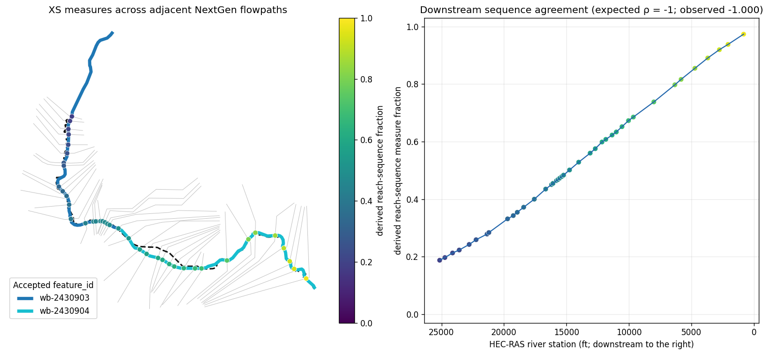
6. Verify along-flowpath measures and XS sequence
Accepted XS links receive measure, fraction, distance from end, method, and
offset on each native NextGen feature. Because this HEC-RAS reach spans two
adjacent wb-* features, the audit also derives a continuous reviewer-only
reach-sequence fraction from the native per-feature measures. HEC-RAS river
stations decrease downstream, so perfect downstream agreement has Spearman
ρ = -1; that sign is expected rather than evidence of reversal.
xs_matches = result.matches.loc[
    (result.matches.element_type == "cross_section")
    & (result.matches.status == "matched")
].copy()
xs_matches["river_station"] = pd.to_numeric(xs_matches.xs_id, errors="coerce")
xs_matches = xs_matches.sort_values("river_station", ascending=False)

flowpath_by_id = flowpaths_model.set_index(flowpaths_model.id.astype(str)).geometry
segment_review = (
    xs_matches.groupby("feature_id")
    .agg(xs_count=("xs_id", "size"), median_station=("river_station", "median"))
    .sort_values("median_station", ascending=False)
)
accepted_ids = segment_review.index.astype(str).tolist()
segment_lengths = {feature_id: flowpath_by_id.loc[feature_id].length for feature_id in accepted_ids}
segment_offsets = {}
running_length = 0.0
for feature_id in accepted_ids:
    segment_offsets[feature_id] = running_length
    running_length += segment_lengths[feature_id]

native_rho = {}
for feature_id in accepted_ids:
    subset = xs_matches.loc[xs_matches.feature_id.astype(str) == feature_id]
    native_rho[feature_id] = (
        subset.river_station.corr(
            subset.flowpath_measure_fraction, method="spearman"
        )
        if len(subset) >= 2
        else np.nan
    )
known_orientations = [
    value for value in native_rho.values()
    if np.isfinite(value) and value != 0
]
if not known_orientations:
    raise ValueError("Cannot infer flowpath orientation from accepted XS measures")
fallback_orientation = float(np.median(known_orientations))

reach_sequence_measure = []
for _, row in xs_matches.iterrows():
    feature_id = str(row.feature_id)
    rho_feature = native_rho[feature_id]
    orientation = (
        rho_feature
        if np.isfinite(rho_feature) and rho_feature != 0
        else fallback_orientation
    )
    downstream_measure = (
        float(row.flowpath_measure)
        if orientation < 0
        else segment_lengths[feature_id] - float(row.flowpath_measure)
    )
    reach_sequence_measure.append(segment_offsets[feature_id] + downstream_measure)
xs_matches["reach_sequence_measure_fraction"] = np.asarray(reach_sequence_measure) / running_length

measure_points=gpd.GeoDataFrame(
    xs_matches.drop(columns="geometry"),
    geometry=[
        flowpath_by_id.loc[str(feature_id)].interpolate(float(measure))
        for feature_id, measure in zip(xs_matches.feature_id, xs_matches.flowpath_measure)
    ],
    crs=result.analysis_crs,
)
rho = xs_matches.river_station.corr(
    xs_matches.reach_sequence_measure_fraction, method="spearman"
)
fig,(amap,aseq)=plt.subplots(1,2,figsize=(15,6.2),gridspec_kw={"width_ratios":[1.35,1]})
cross_sections.plot(ax=amap,color="#bdbdbd",linewidth=.55)
centerlines.plot(ax=amap,color="#111111",linewidth=1.8,linestyle="--")
palette = plt.cm.tab10(np.linspace(0, .9, max(len(accepted_ids), 1)))
segment_colors = dict(zip(accepted_ids, palette))
for feature_id in accepted_ids:
    gpd.GeoSeries([flowpath_by_id.loc[feature_id]], crs=result.analysis_crs).plot(
        ax=amap, color=segment_colors[feature_id], linewidth=4,
        label=feature_id,
    )
scatter=amap.scatter(measure_points.geometry.x,measure_points.geometry.y,
                     c=measure_points.reach_sequence_measure_fraction,
                     cmap="viridis",vmin=0,vmax=1,
                     s=38,edgecolor="white",linewidth=.5,zorder=8)
amap.set_aspect("equal")
amap.set_axis_off()
amap.set_title("XS measures across adjacent NextGen flowpaths")
amap.legend(loc="lower left", title="Accepted feature_id")
fig.colorbar(scatter,ax=amap,fraction=.035,pad=.02,label="derived reach-sequence fraction")
aseq.plot(xs_matches.river_station,xs_matches.reach_sequence_measure_fraction,
          color="#2166ac",lw=1.3)
aseq.scatter(xs_matches.river_station,xs_matches.reach_sequence_measure_fraction,
             c=xs_matches.reach_sequence_measure_fraction,cmap="viridis",vmin=0,vmax=1,
             s=42,edgecolor="white",linewidth=.5)
aseq.invert_xaxis()
aseq.set_ylim(-.03,1.03)
aseq.grid(alpha=.25)
aseq.set_xlabel("HEC-RAS river station (ft; downstream to the right)")
aseq.set_ylabel("derived reach-sequence measure fraction")
aseq.set_title(
    f"Downstream sequence agreement (expected ρ = -1; observed {rho:.3f})"
)
plt.tight_layout()
plt.show()
display(xs_matches[["xs_id","feature_id","flowpath_measure","flowpath_measure_fraction",
                    "flowpath_measure_from_end","measure_method","offset_distance",
                    "reach_sequence_measure_fraction"]].head(12))
| xs_id | feature_id | flowpath_measure | flowpath_measure_fraction | flowpath_measure_from_end | measure_method | offset_distance | reach_sequence_measure_fraction | |
|---|---|---|---|---|---|---|---|---|
| 33 | 25147 | wb-2430903 | 5171.410918 | 0.373366 | 8679.387487 | intersection | 0.0 | 0.187584 |
| 32 | 24729 | wb-2430903 | 5428.774698 | 0.391947 | 8422.023707 | intersection | 0.0 | 0.196920 |
| 31 | 24115 | wb-2430903 | 5868.528629 | 0.423696 | 7982.269776 | intersection | 0.0 | 0.212871 |
| 30 | 23581 | wb-2430903 | 6151.387676 | 0.444118 | 7699.410729 | intersection | 0.0 | 0.223131 |
| 29 | 22786 | wb-2430903 | 6685.343302 | 0.482668 | 7165.455102 | intersection | 0.0 | 0.242500 |
| 28 | 22233 | wb-2430903 | 7138.935835 | 0.515417 | 6711.862570 | intersection | 0.0 | 0.258953 |
| 27 | 21356 | wb-2430903 | 7680.010772 | 0.554481 | 6170.787633 | intersection | 0.0 | 0.278580 |
| 26 | 21208 | wb-2430903 | 7827.801112 | 0.565152 | 6022.997292 | intersection | 0.0 | 0.283940 |
| 24 | 19714 | wb-2430903 | 9138.173712 | 0.659758 | 4712.624693 | intersection | 0.0 | 0.331472 |
| 23 | 19258 | wb-2430903 | 9450.705763 | 0.682322 | 4400.092642 | intersection | 0.0 | 0.342809 |
| 22 | 18938 | wb-2430903 | 9768.807812 | 0.705288 | 4081.990593 | intersection | 0.0 | 0.354347 |
| 21 | 18427 | wb-2430903 | 10254.154562 | 0.740329 | 3596.643843 | intersection | 0.0 | 0.371952 |
7. Review HUC intersections and output invariants
HUC intersections are separate from scoring. These checks verify the output contract without asserting that an external feature must always win as USGS data evolves.
huc_review=result.huc_intersections.drop(columns="geometry").copy()
huc_review["intersection_sq_miles"]=huc_review.intersection_area/(5280.0**2)
display(huc_review[["geometry_id","huc_id","intersection_sq_miles",
                    "geometry_area_fraction","huc_area_fraction"]])
checks = pd.Series({
    "candidate scores bounded [0, 1]": (
        result.candidates.confidence_score.between(0,1).all()
    ),
    "unresolved accepted feature_id values null": (
        result.matches.loc[
            result.matches.status != "matched", "feature_id"
        ].isna().all()
    ),
    "measure fractions bounded [0, 1]": (
        result.matches.flowpath_measure_fraction.dropna().between(0,1).all()
    ),
    "HUC fractions bounded [0, 1]": (
        result.huc_intersections.geometry_area_fraction.between(0,1).all()
    ),
}, name="passed")
assert checks.all()
display(checks.to_frame())
| geometry_id | huc_id | intersection_sq_miles | geometry_area_fraction | huc_area_fraction | |
|---|---|---|---|---|---|
| 0 | lower-colorado-cummins-shiloh-branch | 120903010507 | 2.888101 | 1.0 | 0.053936 |
| passed | |
|---|---|
| candidate scores bounded [0, 1] | True |
| unresolved accepted feature_id values null | True |
| measure fractions bounded [0, 1] | True |
| HUC fractions bounded [0, 1] | True |
Reviewer checklist and next steps
- Confirm the model overlaps the NextGen
wb-*flowpaths andcat-*catchments. - Compare ranks 1 and 2 with alternatives and inspect their direct XS intersections.
- Confirm the winning score uses several independent evidence types.
- Confirm unresolved rows have null accepted IDs but retain candidate evidence.
- Confirm native XS measures form a continuous two-feature NextGen sequence.
This notebook deliberately calls adapter="nextgen" and preserves native
NextGen identifiers throughout. Production thresholds and weights belong to
the consuming workflow and are intentionally not encoded here.