Terrain Modification Layer Writers: Write, Read Back, Verify in RAS Mapper
This notebook drives every RasTerrainModWriter layer kind on a real terrain, reads the
layers back, writes them into a second terrain, and asks RAS Mapper itself to rasterize both.
The writers store layers the way RAS Mapper saves them in HEC-RAS 6.6 and 7.0.1, so RAS
Mapper applies a written layer exactly as it applies one drawn in its own editor.
- Writers:
add_channel_modification,add_high_ground_modification,add_modification_polygon(elevation=...),add_ellipse_modification, andadd_modification_layer, which writes back a layer returned byread_layers. - Inputs: the
BaldEagleCrkMulti2Dexample project (Terrain50), extracted twice byRasExamples: an authored copy and a round-trip copy. - Evidence:
RasTerrain.export_rasmapper_terrain()runs RAS Mapper's own Export to Single Raster on a bounded 3,600-ft window, with modifications off and on, for each installed release among HEC-RAS 6.6 and 7.0.1. The checks compare pixels exactly. - Runtime: about a minute on Windows with HEC-RAS installed. Writing and reading need only
h5py; the exports need a qualified HEC-RAS installation. - Scope: terrain only. No hydraulic plan is run, and the layer elevations are
illustrations, not designs. All outputs stay under
working/.
# =============================================================================
# DEVELOPMENT MODE TOGGLE
# =============================================================================
# True uses this checkout; False uses an installed ras-commander package.

USE_LOCAL_SOURCE = True

import sys
from pathlib import Path

REPO_ROOT = Path.cwd()
if REPO_ROOT.name.lower() == "examples":
    REPO_ROOT = REPO_ROOT.parent

if USE_LOCAL_SOURCE:
    local_path = str(REPO_ROOT)
    if local_path not in sys.path:
        sys.path.insert(0, local_path)
    print("LOCAL SOURCE MODE: Loading from this checkout's ras_commander package")
else:
    print("PIP PACKAGE MODE: Loading installed ras-commander")
LOCAL SOURCE MODE: Loading from this checkout's ras_commander package
import os
import xml.etree.ElementTree as ET

import matplotlib.pyplot as plt
import numpy as np
import pandas as pd
import rasterio
import rasterio.transform
import shapely
from IPython.display import display
from shapely import affinity
from shapely.geometry import LineString, Point, Polygon

from ras_commander import RasExamples, RasTerrain, get_ras_exe
from ras_commander.fim._terrain_mods import read_layers
from ras_commander.terrain import RasTerrainModWriter

RAS_VERSIONS = ("6.6", "7.0.1")  # releases whose saved layer layout the writers follow
TERRAIN_NAME = "Terrain50"
RASMAP_NAME = "BaldEagleDamBrk.rasmap"

# Bounded export window on the BaldEagleCr 2D area (project feet)
X0, Y0, SIZE = 2041060.0, 346430.0, 3600.0
EXPORT_EXTENT = (X0, Y0, X0 + SIZE, Y0 + SIZE)

RUN_ROOT = Path(
    os.environ.get(
        "RAS_COMMANDER_EXAMPLE_RUN_ROOT",
        REPO_ROOT / "working" / "example_321_terrain_modification_layer_writers",
    )
).resolve()
RUN_ROOT.mkdir(parents=True, exist_ok=True)
EXPORT_DIR = RUN_ROOT / "exports"

def run_path(path):
    '''Return a portable label for an artifact under this notebook's run root.'''
    return str(Path("run") / Path(path).resolve().relative_to(RUN_ROOT))

def site(fx, fy):
    '''Map coordinates at fractions (fx, fy) of the export window.'''
    return (X0 + fx * SIZE, Y0 + fy * SIZE)

installed = [v for v in RAS_VERSIONS if Path(get_ras_exe(v)).is_file()]
print(f"Run root: {RUN_ROOT.name}")
print(f"HEC-RAS releases used for the RAS Mapper exports: {installed or 'none installed'}")
Run root: example_321_terrain_modification_layer_writers
HEC-RAS releases used for the RAS Mapper exports: ['6.6', '7.0.1']
Extract two copies of the project
The authored copy receives layers from the individual writers. The round-trip copy starts
from the same unmodified terrain and receives the layers read back from the authored copy.
RasExamples extracts both; the shared example cache is not modified.
copies = {}
for label in ("authored", "roundtrip"):
    copies[label] = RasExamples.extract_project(
        "BaldEagleCrkMulti2D", output_path=RUN_ROOT / "projects", suffix=f"321_{label}"
    )

authored, roundtrip = copies["authored"], copies["roundtrip"]
terrain_a = authored / "Terrain" / f"{TERRAIN_NAME}.hdf"
terrain_b = roundtrip / "Terrain" / f"{TERRAIN_NAME}.hdf"
rasmap_a, rasmap_b = authored / RASMAP_NAME, roundtrip / RASMAP_NAME
for path in (terrain_a, terrain_b, rasmap_a, rasmap_b):
    assert path.exists(), path
    print(run_path(path))
2026-11-12 00:40:45 - ras_commander.RasExamples - ERROR - Failed to save project data to CSV C:\Users\billk_clb\AppData\Local\ras-commander\examples\example_projects.csv: [WinError 183] Cannot create a file when that file already exists: 'C:\\Users\\billk_clb\\AppData\\Local\\ras-commander\\examples'


2026-11-12 00:40:46 - ras_commander.RasExamples - INFO - Successfully extracted project 'BaldEagleCrkMulti2D' to BaldEagleCrkMulti2D_321_authored


2026-11-12 00:40:48 - ras_commander.RasExamples - INFO - Successfully extracted project 'BaldEagleCrkMulti2D' to BaldEagleCrkMulti2D_321_roundtrip


run\projects\BaldEagleCrkMulti2D_321_authored\Terrain\Terrain50.hdf
run\projects\BaldEagleCrkMulti2D_321_roundtrip\Terrain\Terrain50.hdf
run\projects\BaldEagleCrkMulti2D_321_authored\BaldEagleDamBrk.rasmap
run\projects\BaldEagleCrkMulti2D_321_roundtrip\BaldEagleDamBrk.rasmap
Write four layers with the individual writers
Each call writes one layer into the terrain HDF (/Modifications/<name>) and registers it in
the .rasmap under an ElevationModificationGroup. RAS Mapper applies HDF modifications only
when the terrain's .rasmap layer has that group. Each new layer goes on top (Priority 0),
which wins where layers overlap.
| Layer | Writer | Merge mode | Elevation input |
|---|---|---|---|
| Pilot Channel | add_channel_modification |
take_lower (Lower Terrain Value) |
absolute invert profile_points, 548 to 546 ft |
| Training Levee | add_high_ground_modification |
take_higher (Higher Terrain Value) |
constant crest elevation=562 |
| Building Pad | add_modification_polygon |
set_value |
constant elevation=560 |
| Pond and Mound | add_ellipse_modification |
per feature: take_lower pond, take_higher mound |
545 ft pond (circle), 566 ft mound (ellipse rotated 30°) |
A channel invert is always an absolute profile. add_channel_modification(depth=...) is
the alternative: it sets the invert that far below the terrain sampled at each vertex.
channel_line = np.array([site(0.10, 0.20), site(0.45, 0.35), site(0.90, 0.30)])
channel_length = LineString(channel_line).length
RasTerrainModWriter.add_channel_modification(
    terrain_a, rasmap_a, "Pilot Channel", channel_line,
    width=40.0, left_slope=2.0, right_slope=2.0, max_extent=160.0,
    profile_points=[[0.0, 548.0], [channel_length, 546.0]],
)

levee_line = np.array([site(0.10, 0.55), site(0.50, 0.60), site(0.90, 0.55)])
RasTerrainModWriter.add_high_ground_modification(
    terrain_a, rasmap_a, "Training Levee", levee_line,
    top_width=20.0, side_slope=3.0, max_extent=120.0, elevation=562.0,
)

pad_ring = [site(0.15, 0.70), site(0.40, 0.70), site(0.40, 0.90), site(0.15, 0.90)]
RasTerrainModWriter.add_modification_polygon(
    terrain_a, "Building Pad", pad_ring, rasmap_path=rasmap_a,
    elevation=560.0, mode="set_value",
)

pond = dict(center=site(0.65, 0.80), radius_x=200.0, elevation=545.0, mode="take_lower")
mound = dict(center=site(0.82, 0.82), radius_x=220.0, radius_y=90.0, rotation=30.0,
             elevation=566.0, mode="take_higher")
RasTerrainModWriter.add_ellipse_modification(terrain_a, rasmap_a, "Pond and Mound", [pond, mound])

mods = RasTerrainModWriter.list_modifications(terrain_a)
display(mods[["name", "type", "subtype", "priority", "modification_mode", "feature_count"]])

group = ET.parse(rasmap_a).find('.//Layer[@Type="ElevationModificationGroup"]')
print(f"rasmap group {group.get('Name')!r}:",
      [(layer.get("Name"), layer.get("Type")) for layer in group.findall("Layer")])
| name | type | subtype | priority | modification_mode | feature_count | |
|---|---|---|---|---|---|---|
| 0 | Building Pad | Polygon | Multipoint | 1 | set_value | 1 |
| 1 | Pilot Channel | Levee | Channel | 3 | take_lower | 1 |
| 2 | Pond and Mound | Circle | 0 | take_lower | 2 | |
| 3 | Training Levee | Levee | Levee | 2 | take_higher | 1 |
rasmap group 'Modifications': [('Pond and Mound', 'EllipseElevationModificationLayer'), ('Building Pad', 'PolygonElevationModificationLayer'), ('Training Levee', 'GroundLineModificationLayer'), ('Pilot Channel', 'GroundLineModificationLayer')]
Read the layers back
read_layers (in ras_commander.fim._terrain_mods) returns every modification layer of a
terrain HDF in the Fast-Map effective-terrain request form: kind, priority, the per-feature
geometry, profile, merge mode and template values. It refuses forms whose RAS Mapper behavior
is not qualified, so a successful read is also a check on the written layout.
layers = read_layers(terrain_a, length_units="feet", hecras_version="7.0.1")

rows = []
for layer in layers:
    for i, feat in enumerate(layer["features"]):
        rows.append({
            "layer": layer["name"],
            "kind": layer["kind"],
            "priority": layer["priority"],
            "feature": i,
            "elevation_type": feat["elevation_type"],
            "elevation_or_profile": (
                feat.get("elevation")
                if "elevation" in feat
                else f"{feat['profile'][0][1]:.2f} -> {feat['profile'][-1][1]:.2f}"
            ),
            "top_width": feat.get("top_width"),
            "max_reach": feat.get("max_reach"),
            "system_name": feat.get("system_name"),
            "rotation": feat.get("rotation"),
        })
display(pd.DataFrame(rows))
| layer | kind | priority | feature | elevation_type | elevation_or_profile | top_width | max_reach | system_name | rotation | |
|---|---|---|---|---|---|---|---|---|---|---|
| 0 | Building Pad | polygon | 1 | 0 | SetValue | 560.0 | NaN | NaN | NaN | NaN |
| 1 | Pilot Channel | ground_line | 3 | 0 | SetIfLower | 548.00 -> 546.00 | 40.0 | 160.0 | NaN | |
| 2 | Pond and Mound | ellipse | 0 | 0 | SetIfLower | 545.0 | NaN | NaN | NaN | 0.0 |
| 3 | Pond and Mound | ellipse | 0 | 1 | SetIfHigher | 566.0 | NaN | NaN | NaN | 30.0 |
| 4 | Training Levee | ground_line | 2 | 0 | SetIfHigher | 562.00 -> 562.00 | 20.0 | 120.0 | NaN |
Write the read layers into the second terrain
add_modification_layer is the inverse of read_layers. It writes one layer, with all its
features, into another terrain. A new layer goes on top, so writing from the highest
priority number down reproduces the original order. Reading the round-trip terrain must
return the same layers.
for layer in sorted(layers, key=lambda layer: -layer["priority"]):
    RasTerrainModWriter.add_modification_layer(terrain_b, rasmap_b, layer)

layers_b = read_layers(terrain_b, length_units="feet", hecras_version="7.0.1")
print("Round-trip layers:", [(layer["name"], layer["priority"]) for layer in layers_b])
assert layers_b == layers, "read_layers differs after the round trip"
print("read_layers(round-trip terrain) == read_layers(authored terrain)")
Round-trip layers: [('Building Pad', 1), ('Pilot Channel', 3), ('Pond and Mound', 0), ('Training Levee', 2)]
read_layers(round-trip terrain) == read_layers(authored terrain)
Check the terrain with the public reader
RasFim.read_terrain_modifications returns the same layers in a record that also says how
the HEC-RAS version and unit system were resolved, whether every layer can take the native
effective-terrain route (status), and any .rasmap registration problem (warnings). It
never runs the mapping engine. Use it instead of the private _terrain_mods module.
from ras_commander import RasFim

record = RasFim.read_terrain_modifications(terrain_a, rasmap_path=rasmap_a)
fields = ("schema", "method_id", "status", "refusal", "refusal_reason", "hecras_version",
          "hecras_version_basis", "length_units", "length_units_basis", "warnings")
display(pd.Series({name: record[name] for name in fields}, dtype=object).to_frame("value"))
display(pd.DataFrame(
    [(layer["kind"], layer["name"], layer["priority"], len(layer["features"])) for layer in record["layers"]],
    columns=["kind", "name", "priority", "features"],
))
assert record["status"] == "staged" and record["warnings"] == []
assert record["layers"] == read_layers(
    terrain_a, length_units=record["length_units"], hecras_version=record["hecras_version"])
| value | |
|---|---|
| schema | ras-commander-terrain-modifications/1 |
| method_id | rasmapper-effective-terrain/2 |
| status | staged |
| refusal | None |
| refusal_reason | None |
| hecras_version | 7.0.1 |
| hecras_version_basis | Program Version 6.00 in BaldEagleCrkMulti2D_32... |
| length_units | feet |
| length_units_basis | project |
| warnings | [] |
| kind | name | priority | features | |
|---|---|---|---|---|
| 0 | polygon | Building Pad | 1 | 1 |
| 1 | ground_line | Pilot Channel | 3 | 1 |
| 2 | ellipse | Pond and Mound | 0 | 2 |
| 3 | ground_line | Training Levee | 2 | 1 |
Ask RAS Mapper to rasterize the terrains
For each installed release, export the same window three times with RAS Mapper's native
terrain export, at the source resolution (downsample_factor=1):
- authored terrain,
rasterize_modifications=False: the unmodified ground; - authored terrain, modifications on;
- round-trip terrain, modifications on.
A successful export means RAS Mapper loaded every layer. The pixels then show what it applied.
if not installed:
    raise RuntimeError(
        "The RAS Mapper exports below need HEC-RAS 6.6 or 7.0.1 installed (none found by "
        "get_ras_exe); the write and read-back checks above need only h5py."
    )

exports, receipts = {}, []
for version in installed:
    for label, project, rasterize in (
        ("off", authored, False),
        ("authored", authored, True),
        ("roundtrip", roundtrip, True),
    ):
        result = RasTerrain.export_rasmapper_terrain(
            project,
            EXPORT_DIR / f"{version}_{label}.tif",
            terrain_name=TERRAIN_NAME,
            extent=EXPORT_EXTENT,
            downsample_factor=1,
            rasterize_modifications=rasterize,
            overwrite=True,
            hecras_version=version,
        )
        assert result, f"{version} {label}: {result.error}"
        with rasterio.open(result.output_path) as ds:
            exports[(version, label)] = ds.read(1, masked=True)
            transform, shape = ds.transform, ds.shape
        receipts.append({
            "hecras_version": version,
            "terrain": label,
            "modifications": rasterize,
            "success": bool(result),
            "cell_size_ft": result.output_cell_size,
            "shape": shape,
            "seconds": round(result.elapsed_seconds, 1),
            "output": run_path(result.output_path),
        })
display(pd.DataFrame(receipts))
| hecras_version | terrain | modifications | success | cell_size_ft | shape | seconds | output | |
|---|---|---|---|---|---|---|---|---|
| 0 | 6.6 | off | False | True | 20.0 | (181, 181) | 1.4 | run\exports\6.6_off.tif |
| 1 | 6.6 | authored | True | True | 20.0 | (181, 181) | 1.7 | run\exports\6.6_authored.tif |
| 2 | 6.6 | roundtrip | True | True | 20.0 | (181, 181) | 1.6 | run\exports\6.6_roundtrip.tif |
| 3 | 7.0.1 | off | False | True | 20.0 | (181, 181) | 1.6 | run\exports\7.0.1_off.tif |
| 4 | 7.0.1 | authored | True | True | 20.0 | (181, 181) | 1.7 | run\exports\7.0.1_authored.tif |
| 5 | 7.0.1 | roundtrip | True | True | 20.0 | (181, 181) | 1.8 | run\exports\7.0.1_roundtrip.tif |
Round trip: identical pixels
The round-trip terrain must rasterize exactly like the authored one: same values and same nodata mask. With both releases installed, they must also agree on the authored terrain.
def differing_pixels(a, b):
    '''Pixels whose value or nodata state differ.'''
    values = (a.filled(np.nan) != b.filled(np.nan)) & ~(a.mask & b.mask)
    return int((values | (a.mask != b.mask)).sum())

summary = []
for version in installed:
    off = exports[(version, "off")]
    on = exports[(version, "authored")]
    rt = exports[(version, "roundtrip")]
    summary.append({
        "hecras_version": version,
        "pixels_modified": differing_pixels(on, off),
        "roundtrip_vs_authored_differing_pixels": differing_pixels(rt, on),
        "nodata_masks_equal": bool((rt.mask == on.mask).all()),
    })
display(pd.DataFrame(summary))
assert all(row["pixels_modified"] > 0 for row in summary)
assert all(row["roundtrip_vs_authored_differing_pixels"] == 0 for row in summary)
if len(installed) == 2:
    across = differing_pixels(exports[("6.6", "authored")], exports[("7.0.1", "authored")])
    print(f"HEC-RAS 6.6 vs 7.0.1, authored terrain: {across} differing pixels")
    assert across == 0, "HEC-RAS 6.6 and 7.0.1 rasterize the authored terrain differently"
| hecras_version | pixels_modified | roundtrip_vs_authored_differing_pixels | nodata_masks_equal | |
|---|---|---|---|---|
| 0 | 6.6 | 3229 | 0 | True |
| 1 | 7.0.1 | 3229 | 0 | True |
HEC-RAS 6.6 vs 7.0.1, authored terrain: 0 differing pixels
Check each layer against its rule
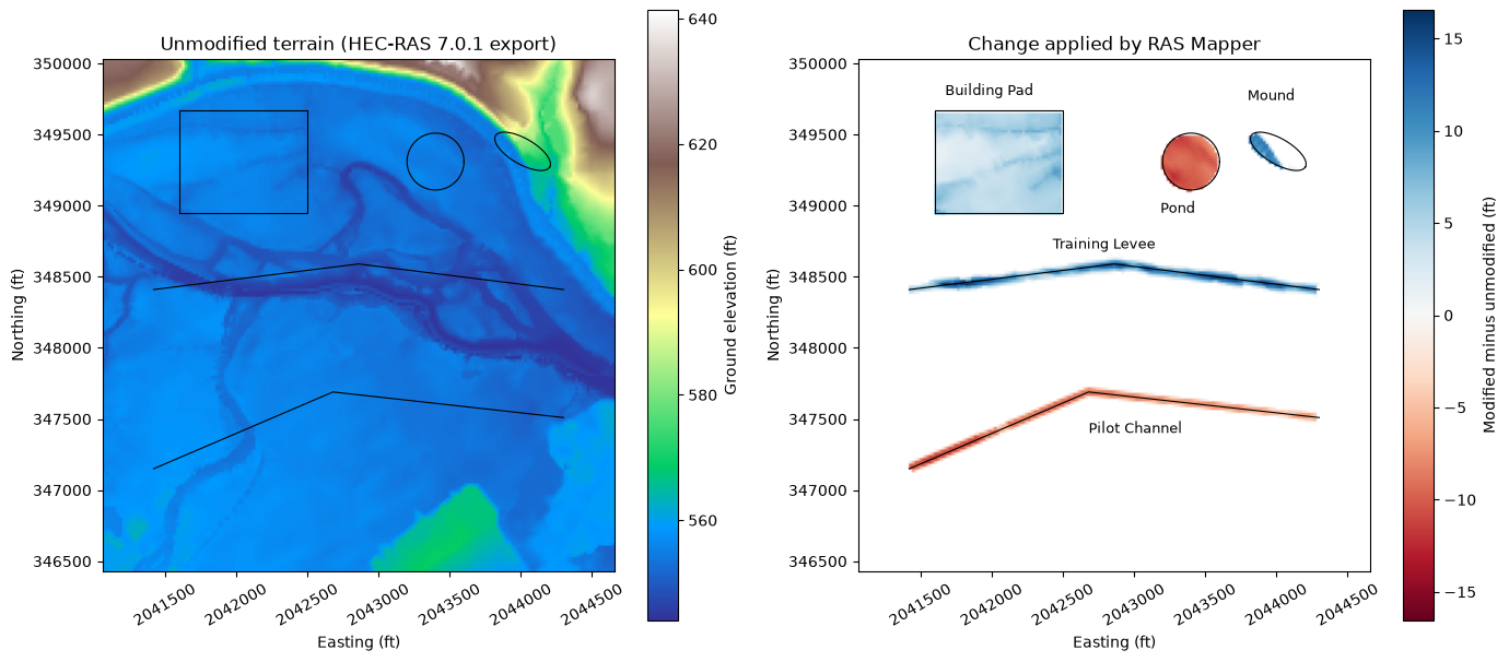
Compare the modified export with the unmodified one, cell by cell, at the cell centres each feature covers:
- Building Pad (
set_value): every cell inside the polygon is 560 ft. - Pond (
take_lower): each cell is the lower of the ground and 545 ft. - Mound (
take_higher): each cell is the higher of the ground and 566 ft. In these exports, the footprint is the ellipse turned 30° clockwise in map view. - Training Levee (
take_higher): along the 20-ft crest, each cell is the higher of the ground and 562 ft. The line ends are left out, because the template is not a simple offset there. - Pilot Channel (
take_lower): across the 40-ft bottom, each cell is the lower of the ground and the invert interpolated at the cell's station. RAS Mapper interpolates the profile at its own stations, so a tolerance of 0.05 ft applies here; the other checks are exact. - Every changed cell lies inside one of the footprints (Max Reach for the lines).
version = installed[-1]
off = exports[(version, "off")].filled(np.nan)
on = exports[(version, "authored")].filled(np.nan)
rows_idx, cols_idx = np.indices(off.shape)
xs, ys = rasterio.transform.xy(transform, rows_idx.ravel(), cols_idx.ravel())
centres = shapely.points(np.asarray(xs), np.asarray(ys)).reshape(off.shape)

pad_poly = Polygon(pad_ring)
pond_poly = Point(pond["center"]).buffer(pond["radius_x"], 256)
mound_poly = affinity.rotate(
    affinity.scale(Point(mound["center"]).buffer(1.0, 256), mound["radius_x"], mound["radius_y"]),
    -mound["rotation"], origin=mound["center"],
)
levee = LineString(levee_line)
channel = LineString(channel_line)

def along(line, half_width):
    '''Cells within half_width of the line, away from its ends.'''
    station = shapely.line_locate_point(line, centres)
    return (shapely.distance(line, centres) <= half_width) & (station > 1) & (station < line.length - 1)

checks = []
def check(name, cells, expected, tolerance=0.0):
    error = float(np.nanmax(np.abs(on[cells] - expected)))
    checks.append({"layer": name, "cells": int(cells.sum()), "max_abs_error_ft": error,
                   "tolerance_ft": tolerance, "pass": error <= tolerance})

cells = shapely.contains(pad_poly, centres)
check("Building Pad", cells, 560.0)
cells = shapely.contains(pond_poly, centres)
check("Pond", cells, np.minimum(off[cells], 545.0))
cells = shapely.contains(mound_poly, centres)
check("Mound", cells, np.maximum(off[cells], 566.0))
cells = along(levee, 10.0)
check("Training Levee crest", cells, np.maximum(off[cells], 562.0))
cells = along(channel, 20.0)
invert = 548.0 + (546.0 - 548.0) * shapely.line_locate_point(channel, centres[cells]) / channel.length
check("Pilot Channel bottom", cells, np.minimum(off[cells], invert), tolerance=0.05)

footprints = (
    (shapely.distance(channel, centres) <= 80.0)
    | (shapely.distance(levee, centres) <= 60.0)
    | shapely.contains(pad_poly.buffer(1.0), centres)
    | shapely.contains(pond_poly.buffer(1.0), centres)
    | shapely.contains(mound_poly.buffer(1.0), centres)
)
changed = on != off
checks.append({"layer": "changed cells outside every footprint", "cells": int((changed & ~footprints).sum()),
               "max_abs_error_ft": None, "tolerance_ft": None, "pass": not (changed & ~footprints).any()})
print(f"HEC-RAS {version} export, {int(changed.sum())} changed cells")
display(pd.DataFrame(checks))
assert all(row["pass"] for row in checks)
HEC-RAS 7.0.1 export, 3229 changed cells
| layer | cells | max_abs_error_ft | tolerance_ft | pass | |
|---|---|---|---|---|---|
| 0 | Building Pad | 1620 | 0.000000 | 0.00 | True |
| 1 | Pond | 312 | 0.000000 | 0.00 | True |
| 2 | Mound | 159 | 0.000000 | 0.00 | True |
| 3 | Training Levee crest | 144 | 0.000000 | 0.00 | True |
| 4 | Pilot Channel bottom | 296 | 0.016449 | 0.05 | True |
| 5 | changed cells outside every footprint | 0 | NaN | NaN | True |
change = np.ma.masked_equal(on - off, 0.0)
extent = (X0, X0 + SIZE, Y0, Y0 + SIZE)
fig, axes = plt.subplots(1, 2, figsize=(14, 6.2))
ground = axes[0].imshow(off, extent=extent, cmap="terrain")
fig.colorbar(ground, ax=axes[0], label="Ground elevation (ft)")
axes[0].set_title(f"Unmodified terrain (HEC-RAS {version} export)")
limit = float(np.nanmax(np.abs(change)))
diff = axes[1].imshow(change, extent=extent, cmap="RdBu", vmin=-limit, vmax=limit)
fig.colorbar(diff, ax=axes[1], label="Modified minus unmodified (ft)")
axes[1].set_title("Change applied by RAS Mapper")
for ax in axes:
    for geom in (channel, levee):
        ax.plot(*geom.xy, color="k", linewidth=0.8)
    for geom in (pad_poly, pond_poly, mound_poly):
        ax.plot(*geom.exterior.xy, color="k", linewidth=0.8)
    ax.set_xlabel("Easting (ft)")
    ax.set_ylabel("Northing (ft)")
    ax.ticklabel_format(useOffset=False, style="plain")
    ax.tick_params(axis="x", labelrotation=30)
for label, xy in (("Pilot Channel", site(0.45, 0.27)), ("Training Levee", site(0.38, 0.63)),
                  ("Building Pad", site(0.17, 0.93)), ("Pond", site(0.59, 0.70)),
                  ("Mound", site(0.76, 0.92))):
    axes[1].annotate(label, xy, fontsize=9)
plt.tight_layout()
plt.show()
Notes and limits
- The writers follow the layout RAS Mapper 6.6 and 7.0.1 save: ground lines with an empty
System Name(a named system takes RAS Mapper's system path, which changes the footprint), NaNTransition Percent, and unique layer priorities with the newest layer on top. add_modification_layerwrites ground lines, constant polygons and ellipses. It refuses layers with control points, boundary-elevation polygons and shape-Z polygons, because it cannot store them so that RAS Mapper applies them the same way.- HEC-RAS 6.6 skips a ground line whose Max Reach is not wider than one terrain cell; 7.0 and 7.0.1 burn it in. The lines here are several cells wide.
- HEC-RAS 7.0.0 has a documented terrain-modification export defect. Use 7.0.1 or later.
- For analysis of modified terrain (profiles, elevation-volume curves), see Terrain Modification Analysis. For hydraulic effects of written modifications, see Terrain Modifications.