Historical Event Validation with AORC Precipitation and USGS Gauges
This notebook demonstrates a comprehensive historical flood event validation workflow using: - AORC gridded precipitation (rain-on-grid on 2D mesh) - USGS gauge data for boundary conditions - Multiple validation points - HUC12 watershed coverage analysis
Event: December 24-25, 2020 storm (2.72 inches, largest 2020 event)
Model: Bald Eagle Creek Multi-2D
Template: Plan 06 (gridded precipitation enabled)
Workflow Overview
- Extract and initialize HEC-RAS project (BaldEagleCrkMulti2D)
- Get project bounds and HUC12 watershed coverage analysis
- Download AORC precipitation data for storm event
- Retrieve USGS gauge data for boundary conditions
- Clone plan and configure for storm simulation
- Run HEC-RAS model
- Extract modeled results and compare with observed USGS data
- Calculate validation metrics and generate comparison plots
# =============================================================================
# IMPORTS AND SETUP
# =============================================================================
from pathlib import Path
import sys

# Flexible imports for development vs installed package
try:
    from ras_commander import RasExamples, init_ras_project, RasCmdr, RasPlan, RasUnsteady, RasUtils, ras
    from ras_commander.hdf import HdfProject, HdfMesh, HdfResultsXsec, HdfResultsMesh
    from ras_commander.precip import PrecipAorc
    from ras_commander.usgs import (
        get_gauge_metadata,
        retrieve_flow_data,
        retrieve_stage_data,
        align_timeseries,
        calculate_all_metrics,
        plot_timeseries_comparison,
        plot_scatter_comparison,
        configure_rate_limit
    )
except ImportError:
    current_file = Path.cwd()
    parent_directory = current_file.parent
    sys.path.insert(0, str(parent_directory))
    from ras_commander import RasExamples, init_ras_project, RasCmdr, RasPlan, RasUnsteady, RasUtils, ras
    from ras_commander.hdf import HdfProject, HdfMesh, HdfResultsXsec, HdfResultsMesh
    from ras_commander.precip import PrecipAorc
    from ras_commander.usgs import (
        get_gauge_metadata,
        retrieve_flow_data,
        retrieve_stage_data,
        align_timeseries,
        calculate_all_metrics,
        plot_timeseries_comparison,
        plot_scatter_comparison,
        configure_rate_limit
    )

import pandas as pd
import numpy as np
import matplotlib.pyplot as plt
import geopandas as gpd
from shapely.geometry import Point

print("Imports successful")
Imports successful
# =============================================================================
# API KEY SETUP
# =============================================================================
# USGS API key provides higher rate limits (5 req/sec vs 0.2 req/sec)
api_key_file = Path("usgs_api_key.txt")

if api_key_file.exists():
    usgs_api_key = api_key_file.read_text().strip()
    configure_rate_limit(requests_per_second=5.0)
    print(f"USGS API key loaded - configured rate limit: 5.0 req/sec")
else:
    usgs_api_key = None
    print("No API key file found - using public access (0.2 req/sec)")
    print("To get higher rate limits, create usgs_api_key.txt with your USGS API key")
No API key file found - using public access (0.2 req/sec)
To get higher rate limits, create usgs_api_key.txt with your USGS API key
# =============================================================================
# PARAMETERS
# =============================================================================
PROJECT_NAME = "BaldEagleCrkMulti2D"
TEMPLATE_PLAN = "06"  # Plan with gridded precipitation enabled
STORM_DATE = "20201224"  # December 24-25, 2020 storm

# Simulation period (48h warmup + event + 48h recession)
SIM_START = "2020-12-22"
SIM_END = "2020-12-27"

# USGS Gauges in Bald Eagle Creek watershed
# 01547500 - Bald Eagle Creek at Blanchard, PA (upstream BC)
# 01548005 - Beech Creek Station (validation point + downstream BC)
UPSTREAM_GAUGE = "01547500"
VALIDATION_GAUGE = "01548005"

# HEC-RAS version
RAS_VERSION = "7.0"

print(f"Project: {PROJECT_NAME}")
print(f"Template Plan: {TEMPLATE_PLAN}")
print(f"Storm Date: {STORM_DATE}")
print(f"Simulation Period: {SIM_START} to {SIM_END}")
print(f"Upstream BC Gauge: {UPSTREAM_GAUGE}")
print(f"Validation Gauge: {VALIDATION_GAUGE}")
Project: BaldEagleCrkMulti2D
Template Plan: 06
Storm Date: 20201224
Simulation Period: 2020-12-22 to 2020-12-27
Upstream BC Gauge: 01547500
Validation Gauge: 01548005
# =============================================================================
# EXTRACT AND INITIALIZE PROJECT
# =============================================================================
suffix = "914_historical"
expected_folder = Path.cwd() / "example_projects" / f"{PROJECT_NAME}_{suffix}"

# Recreate the project copy each run so cloned plans, HDFs, and precipitation
# metadata always reflect the current notebook cells rather than stale artifacts.
if expected_folder.exists():
    print(f"Removing existing project folder: {expected_folder}")
    if not RasUtils.remove_with_retry(expected_folder, ras_object=None):
        raise PermissionError(f"Unable to remove stale project folder: {expected_folder}")

project_folder = RasExamples.extract_project(PROJECT_NAME, suffix=suffix)
print(f"Project extracted to: {project_folder}")

# Initialize project
ras = init_ras_project(project_folder, RAS_VERSION)
print("Project initialized")

# Display available plans
print("\nAvailable plans:")
print(ras.plan_df[['plan_number', 'Plan Title']].to_string())
Removing existing project folder: C:\Users\bill\.config\superpowers\worktrees\ras-commander-pr-docs\codex-pr251-timeseries-alignment\examples\example_projects\BaldEagleCrkMulti2D_914_historical


2026-07-08 21:38:37 - ras_commander.RasExamples - INFO - Successfully extracted project 'BaldEagleCrkMulti2D' to example_projects\BaldEagleCrkMulti2D_914_historical


Project extracted to: C:\Users\bill\.config\superpowers\worktrees\ras-commander-pr-docs\codex-pr251-timeseries-alignment\examples\example_projects\BaldEagleCrkMulti2D_914_historical


2026-07-08 21:38:38 - ras_commander.RasPrj - INFO - ras-commander v0.98.2 | An open-source project of CLB Engineering Corporation (https://clbengineering.com/) | Docs: https://rascommander.info | GitHub: https://github.com/gpt-cmdr/ras-commander


2026-07-08 21:38:38 - ras_commander.RasPrj - INFO - Project initialized: BaldEagleDamBrk


2026-07-08 21:38:38 - ras_commander.RasPrj - INFO - Using HEC-RAS version 7.0


2026-07-08 21:38:38 - ras_commander.RasPrj - INFO -
═══════════════════════════════════════════════════════════════════════
ras-commander | HEC-RAS Automation Library
Docs: https://rascommander.info/
Repo: https://github.com/gpt-cmdr/ras-commander
LLM agents: https://rascommander.info/llms.txt
═══════════════════════════════════════════════════════════════════════

PROJECT DATAFRAMES (single source of truth — use these, not file globbing):
  ras.plan_df        Plans, HDF paths, geometry/flow associations
  ras.geom_df        Geometry files and HDF preprocessor paths
  ras.flow_df        Steady flow files
  ras.unsteady_df    Unsteady flow files and configurations
  ras.boundaries_df  Boundary conditions (type, name, location)
  ras.results_df     Lightweight HDF results summaries
  ras.rasmap_df      RASMapper layers, terrain, land cover paths

KEY APIS (static classes — call directly, never instantiate):
  Execution:    RasCmdr.compute_plan() / compute_parallel() / compute_test_mode()
  Plan Files:   RasPlan.clone_plan() / clone_geom() / set_geom()
  Unsteady:     RasUnsteady — IC/BC management, gate openings, precipitation
  Geometry:     GeomCrossSection, GeomBridge, GeomStorage, GeomLateral, GeomMesh
  HDF Results:  HdfResultsPlan.get_wse() / get_compute_messages()
                HdfResultsMesh.get_mesh_max_ws() / get_mesh_cells_timeseries()
                HdfMesh.get_mesh_cell_points()
  QA/QC:        RasCheck.run_check() / RasFixit (geometry repair)
  DSS:          RasDss.get_timeseries() / check_pathname()
  USGS:         UsgsGaugeSpatial, GaugeMatcher, RasUsgsBoundaryGeneration
  Precipitation: StormGenerator, Atlas14Storm, PrecipAorc, Atlas14Variance
  Terrain:      RasTerrain.create_terrain_hdf() / RasTerrainMod

MULTI-PROJECT: Pass ras_object= to all API calls when using local RasPrj instances.

EXAMPLES: 100+ notebooks in examples/ (100s=execution, 200s=geometry, 300s=unsteady,
  400s=HDF results, 500s=remote, 800s=QA/QC, 900s=data integration).
  Review relevant notebooks before assembling new workflows.

PLATFORM: Most HEC-RAS operations require Windows. Linux/Wine support for
  headless execution, data access, geometry modification, and preprocessing
  is available via RasProcess (HEC-RAS 6.6+). See ras_commander/RasProcess.py.
  Remote distributed execution: ras_commander/remote/ (PsExec, Docker, SSH, cloud).
═══════════════════════════════════════════════════════════════════════


Project initialized

Available plans:
   plan_number                               Plan Title
0           13                  PMF with Multi 2D Areas
1           15              1d-2D Dambreak Refined Grid
2           17                          2D to 1D No Dam
3           18                             2D to 2D Run
4           19                   SA to 2D Dam Break Run
5           03  Single 2D Area - Internal Dam Structure
6           04  SA to 2D Area Conn - 2D Levee Structure
7           02                 SA to Detailed 2D Breach
8           01             SA to Detailed 2D Breach FEQ
9           05          Single 2D area with Bridges FEQ
10          06            Gridded Precip - Infiltration
# =============================================================================
# GET PROJECT BOUNDS FOR AORC DOWNLOAD
# =============================================================================
# Find geometry HDF file
geom_hdf_files = list(project_folder.glob("*.g*.hdf"))
print(f"Found geometry HDF files: {[f.name for f in geom_hdf_files]}")

# Use the most appropriate geometry file (typically highest number with 2D areas)
geom_hdf = None
for f in sorted(geom_hdf_files, reverse=True):
    if f.suffix == '.hdf' and '.g' in f.name:
        geom_hdf = f
        break

if geom_hdf is None:
    raise FileNotFoundError("No geometry HDF file found")

print(f"\nUsing geometry HDF: {geom_hdf.name}")

# Get project bounds in WGS84 for AORC download
# Use 50% buffer to capture upstream precipitation areas
bounds = HdfProject.get_project_bounds_latlon(
    geom_hdf,
    buffer_percent=50.0,
    project_crs="EPSG:2271"  # NAD83 StatePlane Pennsylvania North, US feet
)

print(f"\nProject bounds (WGS84 with 50% buffer):")
print(f"  West:  {bounds[0]:.4f}")
print(f"  South: {bounds[1]:.4f}")
print(f"  East:  {bounds[2]:.4f}")
print(f"  North: {bounds[3]:.4f}")
Found geometry HDF files: ['BaldEagleDamBrk.g01.hdf', 'BaldEagleDamBrk.g02.hdf', 'BaldEagleDamBrk.g03.hdf', 'BaldEagleDamBrk.g06.hdf', 'BaldEagleDamBrk.g08.hdf', 'BaldEagleDamBrk.g09.hdf', 'BaldEagleDamBrk.g10.hdf', 'BaldEagleDamBrk.g11.hdf', 'BaldEagleDamBrk.g12.hdf', 'BaldEagleDamBrk.g13.hdf']

Using geometry HDF: BaldEagleDamBrk.g13.hdf

Project bounds (WGS84 with 50% buffer):
  West:  -77.7085
  South: 41.0102
  East:  -77.2511
  North: 41.2197
# =============================================================================
# DOWNLOAD HUC12 WATERSHED FOR COVERAGE ANALYSIS
# =============================================================================
try:
    from pygeohydro import WBD

    # Get mesh areas for centroid calculation
    mesh_areas = HdfMesh.get_mesh_areas(geom_hdf)
    print(f"Found {len(mesh_areas)} 2D flow areas")

    # Calculate centroid of 2D mesh in WGS84
    mesh_wgs84 = mesh_areas.to_crs("EPSG:4326")
    centroid = mesh_wgs84.geometry.unary_union.centroid
    print(f"\nModel centroid: {centroid.y:.4f}N, {centroid.x:.4f}W")

    # Download HUC12 watershed containing centroid
    wbd = WBD("huc12")
    huc12 = wbd.bygeom(Point(centroid.x, centroid.y), geo_crs="EPSG:4326")

    print(f"\nHUC12 Watershed:")
    print(f"  HUC ID: {huc12.iloc[0]['huc12']}")
    print(f"  Name: {huc12.iloc[0]['name']}")
    print(f"  Area: {huc12.iloc[0]['areasqkm']:.1f} sq km ({huc12.iloc[0]['areasqkm'] * 0.386102:.1f} sq mi)")

    HUC12_AVAILABLE = True

except ImportError:
    print("pygeohydro not available - skipping HUC12 analysis")
    print("Install with: pip install pygeohydro")
    HUC12_AVAILABLE = False
except Exception as e:
    print(f"Error downloading HUC12: {e}")
    HUC12_AVAILABLE = False
pygeohydro not available - skipping HUC12 analysis
Install with: pip install pygeohydro
# =============================================================================
# CALCULATE DRAINAGE COVERAGE
# =============================================================================
if HUC12_AVAILABLE and 'huc12' in dir():
    # Use equal-area projection for accurate area calculations
    # EPSG:5070 (Albers Equal Area Conic) is standard for US applications
    equal_area_crs = "EPSG:5070"

    # Project mesh areas to equal-area CRS for accurate area calculation
    mesh_areas_proj = mesh_areas.to_crs(equal_area_crs)
    mesh_total_area_sqkm = mesh_areas_proj.geometry.area.sum() / 1e6  # m^2 to km^2

    # Use reported area from WBD (already accurate from USGS)
    huc12_area_sqkm = huc12.iloc[0]['areasqkm']

    # Calculate coverage percentage
    coverage_pct = (mesh_total_area_sqkm / huc12_area_sqkm) * 100
    unmodeled_area_sqkm = huc12_area_sqkm - mesh_total_area_sqkm

    print("Drainage Coverage Analysis:")
    print(f"  2D Mesh Area: {mesh_total_area_sqkm:.2f} sq km ({mesh_total_area_sqkm * 0.386102:.2f} sq mi)")
    print(f"  HUC12 Area: {huc12_area_sqkm:.2f} sq km ({huc12_area_sqkm * 0.386102:.2f} sq mi)")
    print(f"  Coverage: {coverage_pct:.1f}%")
    print(f"  Unmodeled Area: {unmodeled_area_sqkm:.2f} sq km ({unmodeled_area_sqkm * 0.386102:.2f} sq mi)")

    if coverage_pct < 80:
        print(f"\nWARNING: Model covers only {coverage_pct:.1f}% of HUC12 drainage area")
        print("  Expect validation discrepancies due to unmodeled runoff contributions")
else:
    print("HUC12 not available - skipping coverage analysis")
HUC12 not available - skipping coverage analysis
# =============================================================================
# CREATE COVERAGE FIGURE
# =============================================================================
from matplotlib.lines import Line2D
from matplotlib.patches import Patch
from matplotlib.ticker import FuncFormatter

if HUC12_AVAILABLE and 'huc12' in dir():
    # Use projected CRS for proper visualization
    vis_crs = "EPSG:5070"  # Albers Equal Area Conic

    fig, ax = plt.subplots(figsize=(12, 10))

    # Project all data to visualization CRS
    huc12_proj = huc12.to_crs(vis_crs)
    mesh_areas_vis = mesh_areas.to_crs(vis_crs)
    legend_handles = [
        Patch(facecolor='lightblue', edgecolor='blue', alpha=0.3, label='HUC12 Watershed'),
        Patch(facecolor='green', edgecolor='darkgreen', alpha=0.5, label='2D Flow Areas'),
    ]
    gauge_roles = set()

    # Plot HUC12 boundary
    huc12_proj.plot(ax=ax, facecolor='lightblue', edgecolor='blue', linewidth=2, alpha=0.3)

    # Plot 2D mesh areas
    mesh_areas_vis.plot(ax=ax, facecolor='green', edgecolor='darkgreen', linewidth=1, alpha=0.5)

    # Add USGS gauge locations if we can retrieve them
    try:
        upstream_meta = get_gauge_metadata(UPSTREAM_GAUGE)
        validation_meta = get_gauge_metadata(VALIDATION_GAUGE)

        # Create gauge points in WGS84
        gauge_points = gpd.GeoDataFrame([
            {'site_id': UPSTREAM_GAUGE, 'name': upstream_meta['station_name'],
             'geometry': Point(upstream_meta['longitude'], upstream_meta['latitude']), 'role': 'Upstream BC'},
            {'site_id': VALIDATION_GAUGE, 'name': validation_meta['station_name'],
             'geometry': Point(validation_meta['longitude'], validation_meta['latitude']), 'role': 'Validation'}
        ], crs="EPSG:4326")

        # Transform to visualization CRS
        gauge_points_proj = gauge_points.to_crs(vis_crs)

        # Plot gauges with different colors
        for idx, row in gauge_points_proj.iterrows():
            color = 'red' if row['role'] == 'Upstream BC' else 'orange'
            gauge_roles.add(row['role'])
            ax.scatter(row.geometry.x, row.geometry.y, c=color, s=150, marker='^',
                      edgecolors='black', linewidths=1.5, zorder=5)
            ax.annotate(f"{row['site_id']}\n({row['role']})",
                       (row.geometry.x, row.geometry.y),
                       xytext=(10, 10), textcoords='offset points', fontsize=9,
                       bbox=dict(boxstyle='round,pad=0.2', facecolor='white', edgecolor='none', alpha=0.75))

    except Exception as e:
        print(f"Could not add gauge locations: {e}")

    if 'Upstream BC' in gauge_roles:
        legend_handles.append(Line2D([0], [0], marker='^', linestyle='None', markersize=10,
                                     markerfacecolor='red', markeredgecolor='black', label='Upstream BC Gauge'))
    if 'Validation' in gauge_roles:
        legend_handles.append(Line2D([0], [0], marker='^', linestyle='None', markersize=10,
                                     markerfacecolor='orange', markeredgecolor='black', label='Validation Gauge'))

    ax.set_title(f"Drainage Coverage Analysis\n{PROJECT_NAME} - HUC12: {huc12.iloc[0]['huc12']}", fontsize=14)
    ax.set_xlabel('Easting (km, EPSG:5070)')
    ax.set_ylabel('Northing (km, EPSG:5070)')
    ax.xaxis.set_major_formatter(FuncFormatter(lambda value, _: f'{value / 1000:,.0f}'))
    ax.yaxis.set_major_formatter(FuncFormatter(lambda value, _: f'{value / 1000:,.0f}'))
    ax.set_aspect('equal', adjustable='box')
    ax.legend(handles=legend_handles, loc='lower right', title='Map Layers', frameon=True, framealpha=0.95)

    # Add coverage annotation
    ax.annotate(f"Coverage: {coverage_pct:.1f}%\nUnmodeled: {unmodeled_area_sqkm:.1f} sq km",
               xy=(0.02, 0.98), xycoords='axes fraction', fontsize=10,
               verticalalignment='top', bbox=dict(boxstyle='round', facecolor='white', alpha=0.8))
    ax.annotate('N', xy=(0.08, 0.18), xytext=(0.08, 0.07), xycoords='axes fraction',
               ha='center', va='center', fontsize=11, fontweight='bold',
               arrowprops=dict(facecolor='black', edgecolor='black', width=2, headwidth=8))

    plt.tight_layout()
    plt.savefig(project_folder / "coverage_analysis.png", dpi=150)
    plt.show()

    print(f"\nCoverage figure saved to: {project_folder / 'coverage_analysis.png'}")
else:
    print("Skipping coverage figure (HUC12 not available)")
Skipping coverage figure (HUC12 not available)
# =============================================================================
# DOWNLOAD AORC PRECIPITATION DATA
# =============================================================================
# Create precipitation folder
precip_folder = project_folder / "Precipitation"
precip_folder.mkdir(exist_ok=True)

aorc_file = precip_folder / f"storm_{STORM_DATE}.nc"

print(f"Downloading AORC precipitation data...")
print(f"  Start: {SIM_START} 00:00")
print(f"  End: {SIM_END} 00:00")
print(f"  Output: {aorc_file}")

try:
    output_path = PrecipAorc.download(
        bounds=bounds,
        start_time=f"{SIM_START} 00:00",
        end_time=f"{SIM_END} 00:00",
        output_path=aorc_file,
        target_crs="EPSG:5070",  # SHG (Standard Hydrologic Grid) for HEC-RAS
        resolution=2000.0  # 2km resolution (standard SHG)
    )
    print(f"\nAORC data downloaded successfully: {output_path}")

    # Get file size
    file_size_mb = output_path.stat().st_size / (1024 * 1024)
    print(f"  File size: {file_size_mb:.2f} MB")

except Exception as e:
    print(f"\nError downloading AORC data: {e}")
    print("Continuing with workflow - manual precipitation setup may be needed")
    aorc_file = None
Downloading AORC precipitation data...
  Start: 2020-12-22 00:00
  End: 2020-12-27 00:00
  Output: C:\Users\bill\.config\superpowers\worktrees\ras-commander-pr-docs\codex-pr251-timeseries-alignment\examples\example_projects\BaldEagleCrkMulti2D_914_historical\Precipitation\storm_20201224.nc


2026-07-08 21:38:38 - ras_commander.precip.PrecipAorc - INFO - Downloading AORC APCP_surface: 2020-12-22 00:00:00 to 2020-12-27 00:00:00, bounds W=-77.7085, S=41.0102, E=-77.2511, N=41.2197


2026-07-08 21:38:44 - ras_commander.precip.PrecipAorc - INFO - AORC download complete: storm_20201224.nc (0.1 MB, 144 timesteps)


AORC data downloaded successfully: C:\Users\bill\.config\superpowers\worktrees\ras-commander-pr-docs\codex-pr251-timeseries-alignment\examples\example_projects\BaldEagleCrkMulti2D_914_historical\Precipitation\storm_20201224.nc
  File size: 0.12 MB
# =============================================================================
# RETRIEVE USGS UPSTREAM BOUNDARY CONDITION DATA
# =============================================================================
print(f"Retrieving upstream BC flow data from gauge {UPSTREAM_GAUGE}...")

# Get gauge metadata
upstream_meta = get_gauge_metadata(UPSTREAM_GAUGE)
print(f"  Station: {upstream_meta['station_name']}")
print(f"  Drainage area: {upstream_meta.get('drainage_area_sqmi', 'N/A')} sq mi")

# Retrieve flow data for simulation period
upstream_flow = retrieve_flow_data(
    site_id=UPSTREAM_GAUGE,
    start_datetime=SIM_START,
    end_datetime=SIM_END,
    data_type='iv'  # Instantaneous values
)

# Remove timezone to match HEC-RAS (timezone-naive)
upstream_flow['datetime'] = pd.to_datetime(upstream_flow['datetime']).dt.tz_localize(None)

print(f"\nRetrieved {len(upstream_flow)} records")
print(f"  Period: {upstream_flow['datetime'].min()} to {upstream_flow['datetime'].max()}")
print(f"  Flow range: {upstream_flow['value'].min():.0f} to {upstream_flow['value'].max():.0f} cfs")
Retrieving upstream BC flow data from gauge 01547500...
2026-07-08 21:38:45 - httpx - INFO - HTTP Request: GET https://waterservices.usgs.gov/nwis/site?sites=01547500&siteOutput=Expanded&format=rdb "HTTP/1.1 200 "
Station: Bald Eagle Creek at Blanchard, PA
Drainage area: 339.0 sq mi
2026-07-08 21:38:45 - httpx - INFO - HTTP Request: GET https://waterservices.usgs.gov/nwis/iv?format=json¶meterCd=00060&startDT=2020-12-22&endDT=2020-12-27&sites=01547500 "HTTP/1.1 301 "
2026-07-08 21:38:46 - httpx - INFO - HTTP Request: GET https://nwis.waterservices.usgs.gov/nwis/iv/?format=json¶meterCd=00060&startDT=2020-12-22&endDT=2020-12-27&sites=01547500 "HTTP/1.1 200 "
Retrieved 576 records
Period: 2020-12-22 05:00:00 to 2020-12-28 04:45:00
Flow range: 1 to 2040 cfs
# =============================================================================
# RETRIEVE USGS VALIDATION DATA
# =============================================================================
print(f"Retrieving validation data from gauge {VALIDATION_GAUGE}...")

# Get gauge metadata
try:
    validation_meta = get_gauge_metadata(VALIDATION_GAUGE)
    print(f"  Station: {validation_meta['station_name']}")
    print(f"  Drainage area: {validation_meta.get('drainage_area_sqmi', 'N/A')} sq mi")
except Exception as e:
    print(f"  Could not retrieve metadata: {e}")
    validation_meta = {'station_name': f'USGS {VALIDATION_GAUGE}'}

# Retrieve flow data for validation
try:
    validation_flow = retrieve_flow_data(
        site_id=VALIDATION_GAUGE,
        start_datetime=SIM_START,
        end_datetime=SIM_END,
        data_type='iv'
    )

    # Remove timezone
    validation_flow['datetime'] = pd.to_datetime(validation_flow['datetime']).dt.tz_localize(None)

    print(f"\nRetrieved {len(validation_flow)} flow records")
    print(f"  Period: {validation_flow['datetime'].min()} to {validation_flow['datetime'].max()}")
    print(f"  Flow range: {validation_flow['value'].min():.0f} to {validation_flow['value'].max():.0f} cfs")

except Exception as e:
    print(f"Error retrieving validation flow data: {e}")
    validation_flow = None

# Retrieve stage data for validation
try:
    validation_stage = retrieve_stage_data(
        site_id=VALIDATION_GAUGE,
        start_datetime=SIM_START,
        end_datetime=SIM_END,
        data_type='iv'
    )

    # Remove timezone
    validation_stage['datetime'] = pd.to_datetime(validation_stage['datetime']).dt.tz_localize(None)

    print(f"\nRetrieved {len(validation_stage)} stage records")
    print(f"  Stage range: {validation_stage['value'].min():.2f} to {validation_stage['value'].max():.2f} ft")

except Exception as e:
    print(f"Stage data not available for gauge {VALIDATION_GAUGE}: {e}")
    validation_stage = None
Retrieving validation data from gauge 01548005...
2026-07-08 21:38:46 - httpx - INFO - HTTP Request: GET https://waterservices.usgs.gov/nwis/site?sites=01548005&siteOutput=Expanded&format=rdb "HTTP/1.1 200 "
2026-07-08 21:38:47 - httpx - INFO - HTTP Request: GET https://waterservices.usgs.gov/nwis/iv?format=json¶meterCd=00060&startDT=2020-12-22&endDT=2020-12-27&sites=01548005 "HTTP/1.1 301 "
Station: Bald Eagle Creek near Beech Creek Station, PA
Drainage area: 562.0 sq mi
2026-07-08 21:38:47 - httpx - INFO - HTTP Request: GET https://nwis.waterservices.usgs.gov/nwis/iv/?format=json¶meterCd=00060&startDT=2020-12-22&endDT=2020-12-27&sites=01548005 "HTTP/1.1 200 "
Retrieved 576 flow records
Period: 2020-12-22 05:00:00 to 2020-12-28 04:45:00
Flow range: 378 to 4340 cfs
2026-07-08 21:38:47 - httpx - INFO - HTTP Request: GET https://waterservices.usgs.gov/nwis/iv?format=json¶meterCd=00065&startDT=2020-12-22&endDT=2020-12-27&sites=01548005 "HTTP/1.1 301 "
2026-07-08 21:38:48 - httpx - INFO - HTTP Request: GET https://nwis.waterservices.usgs.gov/nwis/iv/?format=json¶meterCd=00065&startDT=2020-12-22&endDT=2020-12-27&sites=01548005 "HTTP/1.1 200 "
Retrieved 576 stage records
Stage range: 6.67 to 11.78 ft
# =============================================================================
# PLOT UPSTREAM BC HYDROGRAPH
# =============================================================================
fig, ax = plt.subplots(figsize=(12, 5))

ax.plot(upstream_flow['datetime'], upstream_flow['value'], 'b-', linewidth=1, label='USGS Flow')
ax.fill_between(upstream_flow['datetime'], 0, upstream_flow['value'], alpha=0.2)

# Highlight storm period
storm_start = pd.Timestamp('2020-12-24')
storm_end = pd.Timestamp('2020-12-26')
ax.axvspan(storm_start, storm_end, alpha=0.1, color='red', label='Storm Period')

ax.set_xlabel('Date')
ax.set_ylabel('Flow (cfs)')
ax.set_title(f'Upstream Boundary Condition: USGS {UPSTREAM_GAUGE}\n{upstream_meta["station_name"]}')
ax.legend()
ax.grid(True, alpha=0.3)

plt.tight_layout()
plt.show()

# Calculate peak flow during storm
storm_data = upstream_flow[(upstream_flow['datetime'] >= storm_start) & (upstream_flow['datetime'] <= storm_end)]
print(f"\nStorm Period Statistics ({storm_start.strftime('%Y-%m-%d')} to {storm_end.strftime('%Y-%m-%d')})")
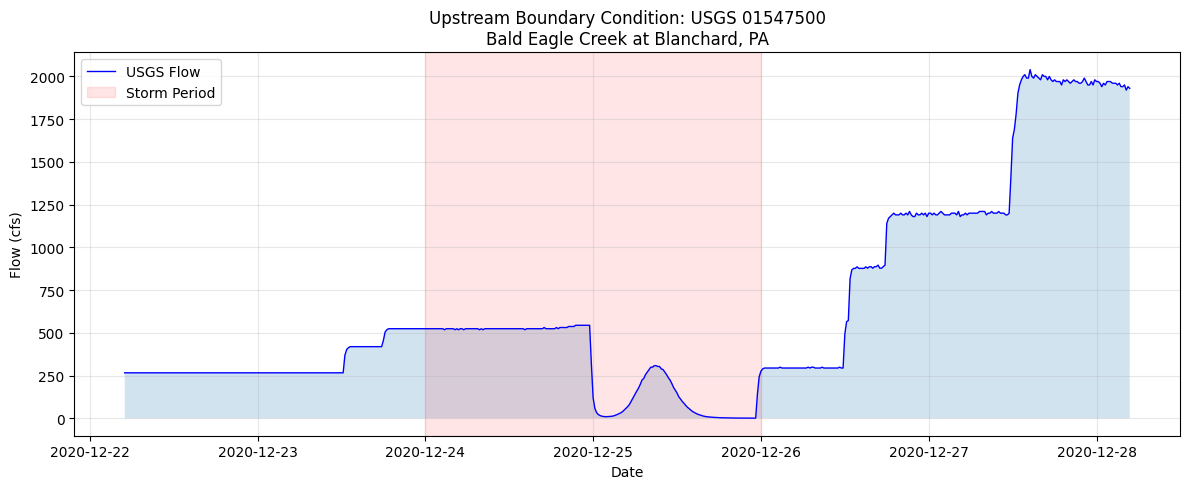
print(f"  Peak flow: {storm_data['value'].max():.0f} cfs")
print(f"  Peak time: {storm_data.loc[storm_data['value'].idxmax(), 'datetime']}")
Storm Period Statistics (2020-12-24 to 2020-12-26)
  Peak flow: 544 cfs
  Peak time: 2020-12-24 21:30:00
# =============================================================================
# CLONE PLAN AND UNSTEADY FILE FOR THE 2020 EVENT
# =============================================================================
print(f"Cloning template plan {TEMPLATE_PLAN} and its unsteady file for {STORM_DATE}...")

sim_start_dt = pd.to_datetime(SIM_START).to_pydatetime()
sim_end_dt = pd.to_datetime(SIM_END).to_pydatetime()
precip_rel_path = Path("Precipitation") / f"storm_{STORM_DATE}.nc"
precip_full_path = project_folder / precip_rel_path

if not precip_full_path.exists():
    raise FileNotFoundError(f"AORC NetCDF file not found: {precip_full_path}")

template_plan_row = ras.plan_df[
    ras.plan_df["plan_number"].astype(str).str.zfill(2).eq(str(TEMPLATE_PLAN).zfill(2))
].iloc[0]
template_unsteady = str(template_plan_row["unsteady_number"]).zfill(2)

# Keep the template 2018 unsteady file intact and isolate the 2020 event in a clone.
new_unsteady = RasPlan.clone_unsteady(
    template_unsteady,
    new_title=f"AORC {STORM_DATE}",
    ras_object=ras,
)
new_plan = RasPlan.clone_plan(
    TEMPLATE_PLAN,
    new_plan_shortid="storm12",
    new_title="AORC Dec 2020 Validation",
    unsteady_flow=new_unsteady,
    ras_object=ras,
)

RasPlan.update_simulation_date(
    new_plan,
    start_date=sim_start_dt,
    end_date=sim_end_dt,
    ras_object=ras,
)
RasUnsteady.set_gridded_precipitation(
    unsteady_file=new_unsteady,
    netcdf_path=precip_rel_path,
    interpolation="Nearest",
    ras_object=ras,
)

# Re-initialize to refresh plan, unsteady, and boundary DataFrames after edits.
ras = init_ras_project(project_folder, RAS_VERSION)

print(f"Created plan {new_plan} using cloned unsteady file u{new_unsteady}")
print(f"Simulation window: {SIM_START} 00:00 to {SIM_END} 00:00")
print(f"AORC precipitation source: {precip_rel_path}")

plan_cols = ["plan_number", "Plan Title", "Simulation Date", "unsteady_number"]
print("\nUpdated event plan:")
display(ras.plan_df.loc[ras.plan_df["plan_number"].astype(str).str.zfill(2).eq(str(new_plan).zfill(2)), plan_cols])
Cloning template plan 06 and its unsteady file for 20201224...


2026-07-08 21:38:49 - ras_commander.RasPlan - INFO - Updated simulation date in plan file: BaldEagleDamBrk.p07


2026-07-08 21:38:50 - ras_commander.RasUnsteady - INFO - Configured gridded precipitation in BaldEagleDamBrk.u04: source=.\Precipitation\storm_20201224.nc, interpolation=Nearest, dataset=APCP_surface


2026-07-08 21:38:50 - ras_commander.RasUnsteady - INFO - Imported gridded precipitation into BaldEagleDamBrk.u04.hdf: 144 timesteps, 352 cells, range=0.0-80.3 mm


2026-07-08 21:38:50 - ras_commander.RasPrj - INFO - ras-commander v0.98.2 | An open-source project of CLB Engineering Corporation (https://clbengineering.com/) | Docs: https://rascommander.info | GitHub: https://github.com/gpt-cmdr/ras-commander


2026-07-08 21:38:50 - ras_commander.RasPrj - INFO - Project initialized: BaldEagleDamBrk


2026-07-08 21:38:50 - ras_commander.RasPrj - INFO - Using HEC-RAS version 7.0


2026-07-08 21:38:50 - ras_commander.RasPrj - INFO -
═══════════════════════════════════════════════════════════════════════
ras-commander | HEC-RAS Automation Library
Docs: https://rascommander.info/
Repo: https://github.com/gpt-cmdr/ras-commander
LLM agents: https://rascommander.info/llms.txt
═══════════════════════════════════════════════════════════════════════

PROJECT DATAFRAMES (single source of truth — use these, not file globbing):
  ras.plan_df        Plans, HDF paths, geometry/flow associations
  ras.geom_df        Geometry files and HDF preprocessor paths
  ras.flow_df        Steady flow files
  ras.unsteady_df    Unsteady flow files and configurations
  ras.boundaries_df  Boundary conditions (type, name, location)
  ras.results_df     Lightweight HDF results summaries
  ras.rasmap_df      RASMapper layers, terrain, land cover paths

KEY APIS (static classes — call directly, never instantiate):
  Execution:    RasCmdr.compute_plan() / compute_parallel() / compute_test_mode()
  Plan Files:   RasPlan.clone_plan() / clone_geom() / set_geom()
  Unsteady:     RasUnsteady — IC/BC management, gate openings, precipitation
  Geometry:     GeomCrossSection, GeomBridge, GeomStorage, GeomLateral, GeomMesh
  HDF Results:  HdfResultsPlan.get_wse() / get_compute_messages()
                HdfResultsMesh.get_mesh_max_ws() / get_mesh_cells_timeseries()
                HdfMesh.get_mesh_cell_points()
  QA/QC:        RasCheck.run_check() / RasFixit (geometry repair)
  DSS:          RasDss.get_timeseries() / check_pathname()
  USGS:         UsgsGaugeSpatial, GaugeMatcher, RasUsgsBoundaryGeneration
  Precipitation: StormGenerator, Atlas14Storm, PrecipAorc, Atlas14Variance
  Terrain:      RasTerrain.create_terrain_hdf() / RasTerrainMod

MULTI-PROJECT: Pass ras_object= to all API calls when using local RasPrj instances.

EXAMPLES: 100+ notebooks in examples/ (100s=execution, 200s=geometry, 300s=unsteady,
  400s=HDF results, 500s=remote, 800s=QA/QC, 900s=data integration).
  Review relevant notebooks before assembling new workflows.

PLATFORM: Most HEC-RAS operations require Windows. Linux/Wine support for
  headless execution, data access, geometry modification, and preprocessing
  is available via RasProcess (HEC-RAS 6.6+). See ras_commander/RasProcess.py.
  Remote distributed execution: ras_commander/remote/ (PsExec, Docker, SSH, cloud).
═══════════════════════════════════════════════════════════════════════


Created plan 07 using cloned unsteady file u04
Simulation window: 2020-12-22 00:00 to 2020-12-27 00:00
AORC precipitation source: Precipitation\storm_20201224.nc

Updated event plan:
| plan_number | Plan Title | Simulation Date | unsteady_number | |
|---|---|---|---|---|
| 11 | 07 | AORC Dec 2020 Validation | 22DEC2020,0000,27DEC2020,0000 | 04 |
# =============================================================================
# VERIFY EVENT INPUT ALIGNMENT
# =============================================================================
plan_row = ras.plan_df.loc[
    ras.plan_df["plan_number"].astype(str).str.zfill(2).eq(str(new_plan).zfill(2))
].iloc[0]
active_unsteady = str(plan_row["unsteady_number"]).zfill(2)

print("Event input alignment check")
print("=" * 70)
print(f"Plan {new_plan} simulation date: {plan_row['Simulation Date']}")
print(f"Plan {new_plan} unsteady file: u{active_unsteady}")
print(f"Precipitation NetCDF: {precip_rel_path}")
print(f"Precipitation file exists: {precip_full_path.exists()}")

boundary_cols = [
    col for col in [
        "unsteady_number", "bc_type", "river_reach_name", "river_station",
        "SA/2D Connection", "Gate Name", "Interval", "Use DSS", "DSS Path"
    ]
    if col in ras.boundaries_df.columns
]
active_boundaries = ras.boundaries_df[
    ras.boundaries_df["unsteady_number"].astype(str).str.zfill(2).eq(active_unsteady)
].copy()
print(f"\nActive boundary rows for u{active_unsteady}: {len(active_boundaries)}")
display(active_boundaries[boundary_cols].head(12) if boundary_cols else active_boundaries.head(12))

print("\nConstraints and assumptions:")
print("- AORC NetCDF precipitation is the active event forcing for this 2020 run.")
print("- The cloned plan, cloned unsteady file, and precipitation source are aligned to the same event window.")
print("- USGS records are used for validation context in this notebook; replacing model boundary hydrographs with observed USGS data is a separate calibration/validation step.")
print("- Gate/control operations are preserved from the template model unless explicitly replaced with observed operations data.")
Event input alignment check
======================================================================
Plan 07 simulation date: 22DEC2020,0000,27DEC2020,0000
Plan 07 unsteady file: u04
Precipitation NetCDF: Precipitation\storm_20201224.nc
Precipitation file exists: True

Active boundary rows for u04: 4
| unsteady_number | bc_type | river_reach_name | river_station | Interval | Use DSS | DSS Path | |
|---|---|---|---|---|---|---|---|
| 51 | 04 | Normal Depth | NaN | NaN | NaN | ||
| 52 | 04 | Flow Hydrograph | 1HOUR | False | |||
| 53 | 04 | Normal Depth | NaN | NaN | NaN | ||
| 54 | 04 | Gate Opening | NaN | NaN | NaN |
Constraints and assumptions:
- AORC NetCDF precipitation is the active event forcing for this 2020 run.
- The cloned plan, cloned unsteady file, and precipitation source are aligned to the same event window.
- USGS records are used for validation context in this notebook; replacing model boundary hydrographs with observed USGS data is a separate calibration/validation step.
- Gate/control operations are preserved from the template model unless explicitly replaced with observed operations data.
Event Forcing Constraints and Assumptions
This notebook now configures the cloned HEC-RAS plan programmatically before execution:
- The 2020 validation plan is isolated in a cloned unsteady-flow file so the original 2018 template event remains unchanged.
- The plan simulation window is
2020-12-22 00:00through2020-12-27 00:00. - The active precipitation source is the downloaded AORC NetCDF file,
Precipitation/storm_20201224.nc. - Existing model boundary hydrographs and gate/control operations are preserved from the template model unless explicitly replaced with observed data.
- USGS records retrieved above are used for validation context. Injecting observed upstream/downstream hydrographs into the active unsteady file is a separate boundary-condition calibration step and is not assumed here.
# =============================================================================
# RUN MODEL (Skip if manual configuration needed)
# =============================================================================
RUN_MODEL = True  # Set to True after manual configuration

if RUN_MODEL:
    print(f"Running plan {new_plan}...")

    try:
        RasCmdr.compute_plan(
            plan_number=new_plan,
            num_cores=4,
            force_rerun=True,
            verify=True,
            ras_object=ras
        )
        print("Model execution complete")

        # Re-initialize to pick up results
        ras = init_ras_project(project_folder, RAS_VERSION)

    except Exception as e:
        print(f"Model execution failed: {e}")
        print("\nCheck that:")
        print("  1. The cloned unsteady file points to the 2020 AORC NetCDF")
        print("  2. Simulation dates match the precipitation data window")
        print("  3. Boundary and gate/control time series cover the plan period")
else:
    print("Model execution skipped - set RUN_MODEL = True after configuration")
    print("\nAlternatively, use existing results from pre-run plan...")
Running plan 07...


Model execution complete


2026-07-08 21:44:07 - ras_commander.RasPrj - INFO - ras-commander v0.98.2 | An open-source project of CLB Engineering Corporation (https://clbengineering.com/) | Docs: https://rascommander.info | GitHub: https://github.com/gpt-cmdr/ras-commander


2026-07-08 21:44:07 - ras_commander.RasPrj - INFO - Project initialized: BaldEagleDamBrk


2026-07-08 21:44:07 - ras_commander.RasPrj - INFO - Using HEC-RAS version 7.0


2026-07-08 21:44:07 - ras_commander.RasPrj - INFO -
═══════════════════════════════════════════════════════════════════════
ras-commander | HEC-RAS Automation Library
Docs: https://rascommander.info/
Repo: https://github.com/gpt-cmdr/ras-commander
LLM agents: https://rascommander.info/llms.txt
═══════════════════════════════════════════════════════════════════════

PROJECT DATAFRAMES (single source of truth — use these, not file globbing):
  ras.plan_df        Plans, HDF paths, geometry/flow associations
  ras.geom_df        Geometry files and HDF preprocessor paths
  ras.flow_df        Steady flow files
  ras.unsteady_df    Unsteady flow files and configurations
  ras.boundaries_df  Boundary conditions (type, name, location)
  ras.results_df     Lightweight HDF results summaries
  ras.rasmap_df      RASMapper layers, terrain, land cover paths

KEY APIS (static classes — call directly, never instantiate):
  Execution:    RasCmdr.compute_plan() / compute_parallel() / compute_test_mode()
  Plan Files:   RasPlan.clone_plan() / clone_geom() / set_geom()
  Unsteady:     RasUnsteady — IC/BC management, gate openings, precipitation
  Geometry:     GeomCrossSection, GeomBridge, GeomStorage, GeomLateral, GeomMesh
  HDF Results:  HdfResultsPlan.get_wse() / get_compute_messages()
                HdfResultsMesh.get_mesh_max_ws() / get_mesh_cells_timeseries()
                HdfMesh.get_mesh_cell_points()
  QA/QC:        RasCheck.run_check() / RasFixit (geometry repair)
  DSS:          RasDss.get_timeseries() / check_pathname()
  USGS:         UsgsGaugeSpatial, GaugeMatcher, RasUsgsBoundaryGeneration
  Precipitation: StormGenerator, Atlas14Storm, PrecipAorc, Atlas14Variance
  Terrain:      RasTerrain.create_terrain_hdf() / RasTerrainMod

MULTI-PROJECT: Pass ras_object= to all API calls when using local RasPrj instances.

EXAMPLES: 100+ notebooks in examples/ (100s=execution, 200s=geometry, 300s=unsteady,
  400s=HDF results, 500s=remote, 800s=QA/QC, 900s=data integration).
  Review relevant notebooks before assembling new workflows.

PLATFORM: Most HEC-RAS operations require Windows. Linux/Wine support for
  headless execution, data access, geometry modification, and preprocessing
  is available via RasProcess (HEC-RAS 6.6+). See ras_commander/RasProcess.py.
  Remote distributed execution: ras_commander/remote/ (PsExec, Docker, SSH, cloud).
═══════════════════════════════════════════════════════════════════════
# =============================================================================
# USE EXISTING PLAN RESULTS (If available)
# =============================================================================
# Check if any plan has HDF results we can use for demonstration
hdf_path = None

for idx, row in ras.plan_df.iterrows():
    hdf_path_str = row.get('HDF_Results_Path')
    if isinstance(hdf_path_str, str) and Path(hdf_path_str).exists():
        hdf_path = Path(hdf_path_str)
        plan_number = row['plan_number']
        print(f"Found existing results: Plan {plan_number}")
        print(f"  HDF: {hdf_path.name}")
        break

if hdf_path is None:
    print("No existing HDF results found.")
    print("Run the model first or use an existing plan with results.")
Found existing results: Plan 07
  HDF: BaldEagleDamBrk.p07.hdf
=============================================================================
VALIDATION: EXTRACT AND COMPARE MODELED VS OBSERVED DATA
=============================================================================
The cells below extract modeled results from the HDF file and compare them
against observed USGS data. This section requires:
1. A completed HEC-RAS run with HDF results (check cell above)
2. validation_meta defined (from cell 11)
3. validation_flow/validation_stage defined (from cell 11)
# =============================================================================
# EXTRACT MODELED RESULTS
# =============================================================================
import h5py

modeled_flow_df = None
modeled_stage_df = None
modeled_df = None  # retained for compatibility with older narrative text
stage_extraction_meta = {}

XSEC_OUTPUT_PATH = (
    "Results/Unsteady/Output/Output Blocks/Base Output/"
    "Unsteady Time Series/Cross Sections"
)
REF_LINE_OUTPUT_PATH = (
    "Results/Unsteady/Output/Output Blocks/Base Output/"
    "Unsteady Time Series/Reference Lines"
)
MESH_TS_ROOT = (
    "Results/Unsteady/Output/Output Blocks/Base Output/"
    "Unsteady Time Series/2D Flow Areas"
)
TIME_STAMP_PATH = (
    "Results/Unsteady/Output/Output Blocks/Base Output/"
    "Unsteady Time Series/Time Date Stamp"
)
PROJECT_CRS = "EPSG:2271"  # Bald Eagle Creek example project CRS (PA StatePlane North, US feet)


def _decode_ras_timestamps(raw_times):
    """Decode HEC-RAS timestamp byte strings into pandas datetimes."""
    decoded = [
        t.decode("utf-8").strip() if isinstance(t, (bytes, bytearray)) else str(t).strip()
        for t in raw_times
    ]
    return pd.to_datetime(decoded, format="%d%b%Y %H:%M:%S")


def _extract_nearest_cell_wse(plan_hdf_path, gauge_meta, project_crs=PROJECT_CRS):
    """Extract WSE time series from the 2D mesh cell nearest the validation gauge."""
    required_meta = {"latitude", "longitude"}
    missing_meta = required_meta.difference(gauge_meta or {})
    if missing_meta:
        raise ValueError(f"Validation gauge metadata is missing: {sorted(missing_meta)}")

    with h5py.File(plan_hdf_path, "r") as hdf:
        if MESH_TS_ROOT not in hdf:
            raise KeyError(f"2D mesh time-series group not found: {MESH_TS_ROOT}")
        if TIME_STAMP_PATH not in hdf:
            raise KeyError(f"Time stamp dataset not found: {TIME_STAMP_PATH}")

        mesh_names = [
            mesh_name for mesh_name in hdf[MESH_TS_ROOT].keys()
            if f"{MESH_TS_ROOT}/{mesh_name}/Water Surface" in hdf
        ]
        if not mesh_names:
            raise KeyError("No 2D mesh Water Surface time-series datasets found")

        mesh_name = mesh_names[0]
        centers_path = f"Geometry/2D Flow Areas/{mesh_name}/Cells Center Coordinate"
        wse_path = f"{MESH_TS_ROOT}/{mesh_name}/Water Surface"
        if centers_path not in hdf:
            raise KeyError(f"Cell-center coordinate dataset not found: {centers_path}")

        centers = hdf[centers_path][:]
        gauge_wgs84 = gpd.GeoDataFrame(
            [{"site_id": VALIDATION_GAUGE}],
            geometry=[Point(float(gauge_meta["longitude"]), float(gauge_meta["latitude"]))],
            crs="EPSG:4326",
        )
        gauge_projected = gauge_wgs84.to_crs(project_crs).geometry.iloc[0]
        distances = np.hypot(centers[:, 0] - gauge_projected.x, centers[:, 1] - gauge_projected.y)
        nearest_cell = int(np.nanargmin(distances))
        distance_ft = float(distances[nearest_cell])
        distance_m = distance_ft * 0.3048006096

        wse_values = hdf[wse_path][:, nearest_cell].astype(float)
        wse_values = np.where(wse_values < -1.0e20, np.nan, wse_values)
        times = _decode_ras_timestamps(hdf[TIME_STAMP_PATH][:])

    modeled_stage = pd.DataFrame({
        "datetime": times,
        "value": wse_values,
    }).dropna()

    meta = {
        "mesh_name": mesh_name,
        "cell_id": nearest_cell,
        "distance_m": distance_m,
        "distance_ft": distance_ft,
        "project_crs": project_crs,
    }
    return modeled_stage, meta


if hdf_path and hdf_path.exists():
    print(f"Extracting modeled results from {hdf_path.name}...")

    # Try 1D cross-section flow only if that output group exists.
    with h5py.File(hdf_path, "r") as hdf:
        has_xsec_output = XSEC_OUTPUT_PATH in hdf
        has_ref_line_output = REF_LINE_OUTPUT_PATH in hdf

    if has_xsec_output:
        print("Attempting to extract 1D cross-section flow results...")
        xs_data = HdfResultsXsec.get_xsec_timeseries(hdf_path)
        xs_names = xs_data.coords["cross_section"].values.tolist()
        station_values = xs_data.coords["Station"].values.tolist()
        time_values = xs_data.coords["time"].values

        target_station = float(station_values[-1]) + (float(station_values[0]) - float(station_values[-1])) * 0.3
        closest_idx = min(range(len(station_values)), key=lambda i: abs(float(station_values[i]) - target_station))
        validation_xs = xs_names[closest_idx]
        modeled_flow_ts = xs_data["Flow"].sel(cross_section=validation_xs)

        modeled_flow_df = pd.DataFrame({
            "datetime": pd.to_datetime(time_values),
            "value": modeled_flow_ts.values,
        })
        modeled_df = modeled_flow_df

        print("\nModeled flow results (1D cross-section):")
        print(f"  Cross sections: {len(xs_names)}")
        print(f"  Validation cross section: {validation_xs} (station {station_values[closest_idx]})")
        print(f"  Period: {modeled_flow_df['datetime'].min()} to {modeled_flow_df['datetime'].max()}")
        print(f"  Flow range: {modeled_flow_df['value'].min():.1f} to {modeled_flow_df['value'].max():.1f} cfs")
    else:
        print("1D cross-section flow output is not present in this plan HDF.")

    # Try 2D reference-line flow next. Empty reference-line output is expected in this example project.
    if modeled_flow_df is None and has_ref_line_output:
        print("\nAttempting to extract 2D reference-line flow results...")
        ref_lines_data = HdfResultsXsec.get_ref_lines_timeseries(hdf_path)
        if ref_lines_data and len(ref_lines_data.data_vars) > 0 and "Flow" in ref_lines_data.data_vars:
            ref_line_names = ref_lines_data.coords["ref_line"].values.tolist()
            validation_ref_line = ref_line_names[0]
            modeled_flow_ts = ref_lines_data["Flow"].sel(ref_line=validation_ref_line)
            modeled_flow_df = pd.DataFrame({
                "datetime": pd.to_datetime(ref_lines_data.coords["time"].values),
                "value": modeled_flow_ts.values,
            })
            modeled_df = modeled_flow_df

            print("\nModeled flow results (2D reference line):")
            print(f"  Reference line: {validation_ref_line}")
            print(f"  Period: {modeled_flow_df['datetime'].min()} to {modeled_flow_df['datetime'].max()}")
            print(f"  Flow range: {modeled_flow_df['value'].min():.1f} to {modeled_flow_df['value'].max():.1f} cfs")
        else:
            print("2D reference-line flow output is empty or does not include Flow.")
    elif modeled_flow_df is None:
        print("2D reference-line flow output is not present in this plan HDF.")

    # If no defensible flow time series exists, extract nearest-cell WSE for stage validation.
    if modeled_flow_df is None:
        print("\nFlow validation requires a cross section, 2D reference line, or face-flow integration.")
        print("Falling back to nearest-cell 2D Water Surface Elevation for stage validation...")
        try:
            modeled_stage_df, stage_extraction_meta = _extract_nearest_cell_wse(hdf_path, validation_meta)
            modeled_df = modeled_stage_df
            print("\nModeled stage results (nearest 2D mesh cell WSE):")
            print(f"  Mesh area: {stage_extraction_meta['mesh_name']}")
            print(f"  Cell ID: {stage_extraction_meta['cell_id']}")
            print(
                f"  Distance from validation gauge: "
                f"{stage_extraction_meta['distance_ft']:.0f} ft "
                f"({stage_extraction_meta['distance_m']:.1f} m)"
            )
            print(f"  Period: {modeled_stage_df['datetime'].min()} to {modeled_stage_df['datetime'].max()}")
            print(f"  WSE range: {modeled_stage_df['value'].min():.2f} to {modeled_stage_df['value'].max():.2f} ft")
        except Exception as stage_error:
            print(f"  Could not extract nearest-cell stage series: {stage_error}")
            modeled_stage_df = None

    if modeled_flow_df is None and modeled_stage_df is None:
        print("\n" + "="*70)
        print("WARNING: Could not extract modeled flow or stage time series from the model results.")
        print("="*70)
        print("Options:")
        print("  1. Add a reference line in HEC-RAS at the validation gauge location")
        print("  2. Add a reference point or extract a reviewed 2D mesh-cell WSE location")
        print("  3. Calculate flow from face velocities with a reviewed cutline")
        print("="*70)
else:
    print("No HDF results available for extraction")
Extracting modeled results from BaldEagleDamBrk.p07.hdf...
1D cross-section flow output is not present in this plan HDF.
2D reference-line flow output is not present in this plan HDF.

Flow validation requires a cross section, 2D reference line, or face-flow integration.
Falling back to nearest-cell 2D Water Surface Elevation for stage validation...


Modeled stage results (nearest 2D mesh cell WSE):
  Mesh area: BaldEagleCr
  Cell ID: 10562
  Distance from validation gauge: 97 ft (29.6 m)
  Period: 2020-12-22 00:00:00 to 2020-12-27 00:00:00
  WSE range: 562.58 to 573.83 ft
# =============================================================================
# ALIGN AND CALCULATE VALIDATION METRICS
# =============================================================================
aligned_flow = None
flow_metrics = None
aligned_stage = None
stage_metrics = None
observed_stage_wse = None


def _align_to_model_times(modeled_series, observed_series):
    """Interpolate observed values to modeled timestamps over their overlap."""
    model = modeled_series[["datetime", "value"]].dropna().sort_values("datetime").copy()
    obs = observed_series[["datetime", "value"]].dropna().sort_values("datetime").copy()
    model["datetime"] = pd.to_datetime(model["datetime"])
    obs["datetime"] = pd.to_datetime(obs["datetime"])

    overlap_start = max(model["datetime"].min(), obs["datetime"].min())
    overlap_end = min(model["datetime"].max(), obs["datetime"].max())
    if overlap_start >= overlap_end:
        raise ValueError(
            f"No overlapping time period. Model: {model['datetime'].min()} to {model['datetime'].max()}, "
            f"Observed: {obs['datetime'].min()} to {obs['datetime'].max()}"
        )

    model = model[(model["datetime"] >= overlap_start) & (model["datetime"] <= overlap_end)].copy()
    obs = obs[(obs["datetime"] >= overlap_start) & (obs["datetime"] <= overlap_end)].copy()

    model_seconds = model["datetime"].astype("int64") / 1e9
    obs_seconds = obs["datetime"].astype("int64") / 1e9
    observed_interp = np.interp(model_seconds, obs_seconds, obs["value"].astype(float))

    return pd.DataFrame({
        "datetime": model["datetime"].values,
        "modeled": model["value"].astype(float).values,
        "observed": observed_interp,
    })


if modeled_flow_df is not None and validation_flow is not None:
    print("Aligning modeled and observed flow timeseries...")

    aligned_flow = align_timeseries(
        modeled_df=modeled_flow_df,
        observed_df=validation_flow,
    )

    print(f"\nAligned {len(aligned_flow)} timesteps")
    print(f"  Period: {aligned_flow['datetime'].min()} to {aligned_flow['datetime'].max()}")
    print(f"  Modeled range: {aligned_flow['modeled'].min():.1f} to {aligned_flow['modeled'].max():.1f} cfs")
    print(f"  Observed range: {aligned_flow['observed'].min():.1f} to {aligned_flow['observed'].max():.1f} cfs")

    print("\nCalculating flow validation metrics...")
    flow_metrics = calculate_all_metrics(
        observed=aligned_flow["observed"],
        modeled=aligned_flow["modeled"],
        time_index=aligned_flow["datetime"],
    )

    print("\n" + "="*60)
    print("FLOW VALIDATION METRICS")
    print("="*60)
    print(f"Nash-Sutcliffe Efficiency (NSE): {flow_metrics['nse']:.3f}")
    print(f"Kling-Gupta Efficiency (KGE): {flow_metrics['kge']:.3f}")
    print(f"Peak Flow Error: {flow_metrics['peak_error_pct']:.1f}%")
    print(f"Volume Error: {flow_metrics['vol_error_pct']:.1f}%")
    print(f"RMSE: {flow_metrics['rmse']:.1f} cfs")
elif modeled_stage_df is not None and validation_stage is not None:
    print("Aligning modeled WSE and observed USGS stage timeseries...")

    gage_datum_ft = validation_meta.get("gage_datum_ft") if validation_meta else None
    if gage_datum_ft is None:
        print("Cannot calculate stage metrics because the USGS gage datum is unavailable.")
    else:
        observed_stage_wse = validation_stage.copy()
        observed_stage_wse["value"] = pd.to_numeric(observed_stage_wse["value"], errors="coerce") + float(gage_datum_ft)

        aligned_stage = _align_to_model_times(modeled_stage_df, observed_stage_wse)
        residuals = aligned_stage["modeled"] - aligned_stage["observed"]
        model_peak_idx = aligned_stage["modeled"].idxmax()
        obs_peak_idx = aligned_stage["observed"].idxmax()
        peak_time_error_hr = (
            aligned_stage.loc[model_peak_idx, "datetime"] - aligned_stage.loc[obs_peak_idx, "datetime"]
        ) / pd.Timedelta(hours=1)

        stage_metrics = {
            "gage_datum_ft": float(gage_datum_ft),
            "bias_ft": float(residuals.mean()),
            "rmse_ft": float(np.sqrt(np.mean(residuals ** 2))),
            "mae_ft": float(np.mean(np.abs(residuals))),
            "peak_error_ft": float(aligned_stage["modeled"].max() - aligned_stage["observed"].max()),
            "peak_time_error_hr": float(peak_time_error_hr),
            "n_points": int(len(aligned_stage)),
        }

        print(f"\nAligned {len(aligned_stage)} timesteps")
        print(f"  Period: {aligned_stage['datetime'].min()} to {aligned_stage['datetime'].max()}")
        print(f"  USGS gage datum: {gage_datum_ft:.2f} ft")
        print(f"  Modeled WSE range: {aligned_stage['modeled'].min():.2f} to {aligned_stage['modeled'].max():.2f} ft")
        print(f"  Observed WSE range: {aligned_stage['observed'].min():.2f} to {aligned_stage['observed'].max():.2f} ft")

        print("\n" + "="*60)
        print("STAGE / WSE VALIDATION METRICS")
        print("="*60)
        print(f"Bias: {stage_metrics['bias_ft']:.2f} ft")
        print(f"RMSE: {stage_metrics['rmse_ft']:.2f} ft")
        print(f"Mean Absolute Error: {stage_metrics['mae_ft']:.2f} ft")
        print(f"Peak Stage Error: {stage_metrics['peak_error_ft']:.2f} ft")
        print(f"Peak Timing Error: {stage_metrics['peak_time_error_hr']:.2f} hours")
else:
    print("Cannot calculate metrics - missing modeled or observed flow/stage data")
Aligning modeled WSE and observed USGS stage timeseries...

Aligned 691 timesteps
  Period: 2020-12-22 05:00:00 to 2020-12-27 00:00:00
  USGS gage datum: 559.25 ft
  Modeled WSE range: 562.58 to 573.83 ft
  Observed WSE range: 565.92 to 571.03 ft

============================================================
STAGE / WSE VALIDATION METRICS
============================================================
Bias: 1.29 ft
RMSE: 2.67 ft
Mean Absolute Error: 2.01 ft
Peak Stage Error: 2.80 ft
Peak Timing Error: 37.67 hours
# =============================================================================
# PLOT TIMESERIES COMPARISON
# =============================================================================
if aligned_flow is not None:
    fig = plot_timeseries_comparison(
        aligned_data=aligned_flow,
        metrics=flow_metrics,
        title=f"Flow Validation: {validation_meta.get('station_name', VALIDATION_GAUGE)}",
    )

    plt.tight_layout()
    plt.savefig(project_folder / "flow_validation.png", dpi=150)
    plt.show()

    print(f"\nFigure saved to: {project_folder / 'flow_validation.png'}")
elif aligned_stage is not None:
    fig, ax = plt.subplots(figsize=(12, 6))
    ax.plot(aligned_stage["datetime"], aligned_stage["observed"], "b-", linewidth=1.4, label="Observed USGS WSE")
    ax.plot(aligned_stage["datetime"], aligned_stage["modeled"], "r--", linewidth=1.4, label="Modeled nearest-cell WSE")
    ax.set_xlabel("Date")
    ax.set_ylabel("Water Surface Elevation (ft)")
    ax.set_title(f"Stage/WSE Validation: {validation_meta.get('station_name', VALIDATION_GAUGE)}")
    ax.grid(True, alpha=0.3)
    ax.legend(loc="best")

    metrics_text = (
        f"Datum = {stage_metrics['gage_datum_ft']:.2f} ft\n"
        f"Bias = {stage_metrics['bias_ft']:.2f} ft\n"
        f"RMSE = {stage_metrics['rmse_ft']:.2f} ft\n"
        f"Peak error = {stage_metrics['peak_error_ft']:.2f} ft"
    )
    ax.text(
        0.02, 0.98, metrics_text,
        transform=ax.transAxes,
        va="top",
        fontfamily="monospace",
        fontsize=9,
        bbox={"boxstyle": "round", "facecolor": "white", "alpha": 0.85},
    )

    plt.tight_layout()
    plt.savefig(project_folder / "stage_validation.png", dpi=150)
    plt.show()

    print(f"\nFigure saved to: {project_folder / 'stage_validation.png'}")
else:
    print("Cannot plot comparison - missing aligned data")
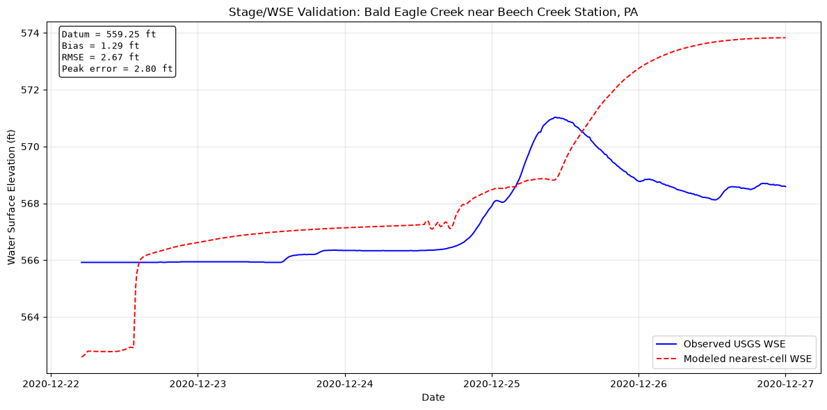
Figure saved to: C:\Users\bill\.config\superpowers\worktrees\ras-commander-pr-docs\codex-pr251-timeseries-alignment\examples\example_projects\BaldEagleCrkMulti2D_914_historical\stage_validation.png
# =============================================================================
# PLOT SCATTER / RESIDUAL COMPARISON
# =============================================================================
if aligned_flow is not None:
    fig, axes = plt.subplots(1, 2, figsize=(14, 6))
    ax1, ax2 = axes

    ax1.scatter(aligned_flow["observed"], aligned_flow["modeled"], alpha=0.5, s=10)
    max_val = max(aligned_flow["observed"].max(), aligned_flow["modeled"].max())
    ax1.plot([0, max_val], [0, max_val], "r--", label="1:1 Line")
    ax1.set_xlabel("Observed Flow (cfs)")
    ax1.set_ylabel("Modeled Flow (cfs)")
    ax1.set_title(f"Flow Scatter Plot\nNSE={flow_metrics['nse']:.3f}, KGE={flow_metrics['kge']:.3f}")
    ax1.legend()
    ax1.grid(True, alpha=0.3)
    ax1.set_aspect("equal")

    residuals = aligned_flow["modeled"] - aligned_flow["observed"]
    ax2.hist(residuals, bins=50, edgecolor="black", alpha=0.7)
    ax2.axvline(x=0, color="r", linestyle="--", label="Zero Error")
    ax2.axvline(x=residuals.mean(), color="g", linestyle="-", label=f"Mean: {residuals.mean():.0f} cfs")
    ax2.set_xlabel("Residual (Modeled - Observed) [cfs]")
    ax2.set_ylabel("Count")
    ax2.set_title("Residuals Distribution")
    ax2.legend()
    ax2.grid(True, alpha=0.3)

    plt.tight_layout()
    plt.savefig(project_folder / "flow_scatter.png", dpi=150)
    plt.show()

    print(f"\nFigure saved to: {project_folder / 'flow_scatter.png'}")
elif aligned_stage is not None:
    fig, axes = plt.subplots(1, 2, figsize=(14, 6))
    ax1, ax2 = axes

    min_val = min(aligned_stage["observed"].min(), aligned_stage["modeled"].min())
    max_val = max(aligned_stage["observed"].max(), aligned_stage["modeled"].max())
    pad = max((max_val - min_val) * 0.05, 0.5)

    ax1.scatter(aligned_stage["observed"], aligned_stage["modeled"], alpha=0.5, s=10, color="darkorange")
    ax1.plot([min_val - pad, max_val + pad], [min_val - pad, max_val + pad], "k--", label="1:1 Line")
    ax1.set_xlabel("Observed WSE (ft)")
    ax1.set_ylabel("Modeled WSE (ft)")
    ax1.set_title(f"Stage/WSE Scatter\nRMSE={stage_metrics['rmse_ft']:.2f} ft, Bias={stage_metrics['bias_ft']:.2f} ft")
    ax1.legend()
    ax1.grid(True, alpha=0.3)
    ax1.set_aspect("equal", adjustable="box")
    ax1.set_xlim(min_val - pad, max_val + pad)
    ax1.set_ylim(min_val - pad, max_val + pad)

    residuals = aligned_stage["modeled"] - aligned_stage["observed"]
    ax2.hist(residuals, bins=40, edgecolor="black", alpha=0.75, color="steelblue")
    ax2.axvline(x=0, color="r", linestyle="--", label="Zero Error")
    ax2.axvline(x=residuals.mean(), color="g", linestyle="-", label=f"Mean: {residuals.mean():.2f} ft")
    ax2.set_xlabel("Residual (Modeled - Observed) [ft]")
    ax2.set_ylabel("Count")
    ax2.set_title("Stage/WSE Residuals")
    ax2.legend()
    ax2.grid(True, alpha=0.3)

    plt.tight_layout()
    plt.savefig(project_folder / "stage_scatter.png", dpi=150)
    plt.show()

    print(f"\nFigure saved to: {project_folder / 'stage_scatter.png'}")
else:
    print("Cannot plot scatter - missing aligned data")
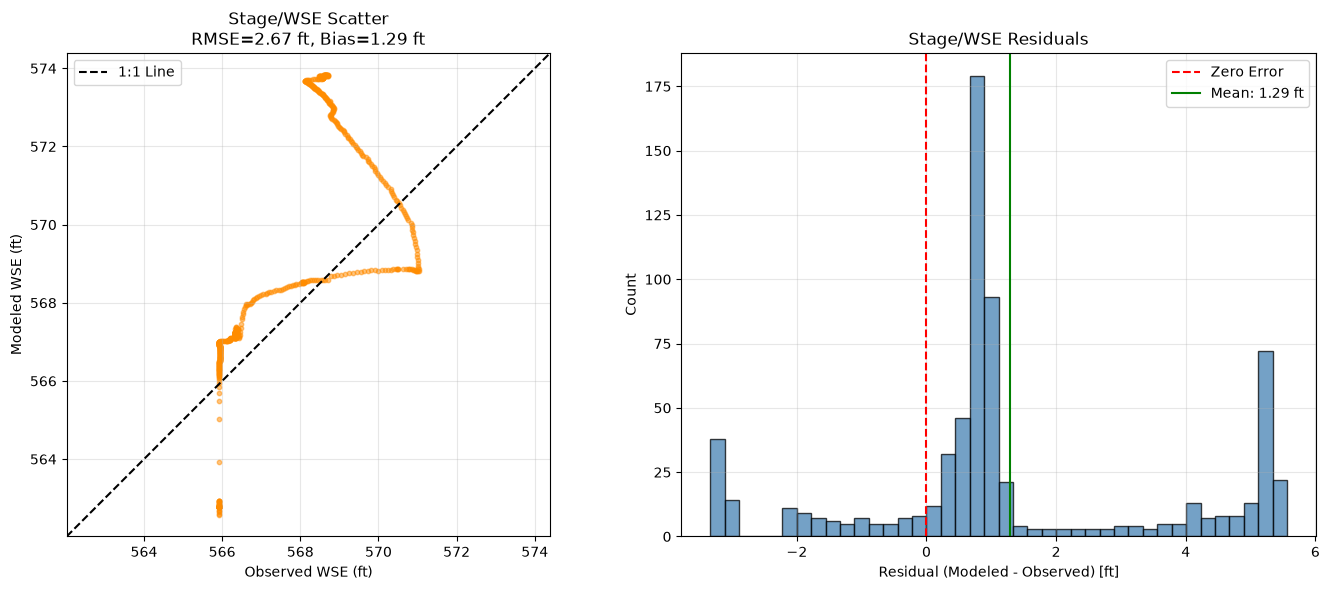
Figure saved to: C:\Users\bill\.config\superpowers\worktrees\ras-commander-pr-docs\codex-pr251-timeseries-alignment\examples\example_projects\BaldEagleCrkMulti2D_914_historical\stage_scatter.png
Results Summary
Flow vs Stage Validation
This example first attempts flow validation from 1D cross-section output or 2D reference-line output. The active plan is a 2D-focused example and does not include a flow cutline/reference line at the downstream validation gauge, so the automated comparison falls back to stage validation:
- Modeled value: 2D mesh-cell Water Surface Elevation at the cell nearest USGS
01548005. - Observed value: USGS gage height plus the reported USGS gage datum (
gage_datum_ft). - Flow validation remains a model-development follow-up that requires adding a reviewed 2D reference line/cutline or computing flow from face velocities across a reviewed section.
Stage/WSE Metrics
Bias: mean modeled WSE minus observed WSE. Positive values indicate the model is high on average.
RMSE: root mean square stage error in feet.
Peak Stage Error: modeled peak WSE minus observed peak WSE.
Peak Timing Error: modeled peak time minus observed peak time in hours.
Expected Limitations
-
Drainage Area Mismatch: The 2D model may not cover the entire HUC12 watershed, leading to missing runoff contributions from unmodeled areas.
-
USGS Gauge Location: The validation gauge may be downstream of significant unmodeled tributaries.
-
Precipitation Spatial Variability: AORC data at 4km resolution may not capture localized intense precipitation.
-
Boundary Condition Uncertainty: USGS observations are used for validation context, while the active model run preserves the template model boundary hydrographs unless a later calibration step explicitly replaces them.
-
Operations Data Constraint: Gate/control operations are preserved from the example model. Observed operations data are not included with this notebook.
-
Point-Cell Stage Approximation: Nearest-cell WSE is appropriate for a demonstration fallback, but a professional validation should verify the gauge location, local datum, mesh resolution, and result extraction point.
Recommendations
-
Add a Reviewed Flow Cutline: Add a 2D reference line at the validation gauge if flow metrics are needed.
-
Expand Model Domain: Consider extending the 2D mesh to cover more of the watershed.
-
Additional Validation Points: Add more USGS gauges if available within the model domain.
-
Sensitivity Analysis: Test sensitivity to Manning's n, precipitation, and initial conditions.
-
Multiple Events: Validate against multiple storm events to assess model robustness.
# =============================================================================
# SUMMARY REPORT
# =============================================================================
print("="*70)
print("HISTORICAL EVENT VALIDATION SUMMARY")
print("="*70)
print(f"\nProject: {PROJECT_NAME}")
print(f"Storm Event: December 24-25, 2020")
print(f"Simulation Period: {SIM_START} to {SIM_END}")

print(f"\nData Sources:")
print(f"  Precipitation: AORC gridded data (4km, hourly)")
print(f"  Upstream BC: USGS {UPSTREAM_GAUGE}")
print(f"  Validation: USGS {VALIDATION_GAUGE}")

if HUC12_AVAILABLE and "coverage_pct" in dir():
    print(f"\nDrainage Coverage:")
    print(f"  Model covers {coverage_pct:.1f}% of HUC12 watershed")
    print(f"  Unmodeled area: {unmodeled_area_sqkm:.1f} sq km")

if flow_metrics is not None:
    print(f"\nFlow Validation Metrics:")
    print(f"  NSE: {flow_metrics['nse']:.3f}")
    print(f"  KGE: {flow_metrics['kge']:.3f}")
    print(f"  Peak Error: {flow_metrics['peak_error_pct']:.1f}%")
    print(f"  Volume Error: {flow_metrics['vol_error_pct']:.1f}%")
elif stage_metrics is not None:
    print(f"\nStage/WSE Validation Metrics:")
    print(f"  Gage datum: {stage_metrics['gage_datum_ft']:.2f} ft")
    print(f"  Bias: {stage_metrics['bias_ft']:.2f} ft")
    print(f"  RMSE: {stage_metrics['rmse_ft']:.2f} ft")
    print(f"  Mean Absolute Error: {stage_metrics['mae_ft']:.2f} ft")
    print(f"  Peak Stage Error: {stage_metrics['peak_error_ft']:.2f} ft")
    print(f"  Peak Timing Error: {stage_metrics['peak_time_error_hr']:.2f} hours")
    if stage_extraction_meta:
        print(
            f"  Extraction point: {stage_extraction_meta['mesh_name']} cell "
            f"{stage_extraction_meta['cell_id']} "
            f"({stage_extraction_meta['distance_ft']:.0f} ft from gauge)"
        )
    print("  Flow metrics not calculated because no reviewed flow cutline/reference line is present.")

print(f"\nOutput Files:")
if (project_folder / "coverage_analysis.png").exists():
    print(f"  - {project_folder / 'coverage_analysis.png'}")
if (project_folder / "flow_validation.png").exists():
    print(f"  - {project_folder / 'flow_validation.png'}")
if (project_folder / "flow_scatter.png").exists():
    print(f"  - {project_folder / 'flow_scatter.png'}")
if (project_folder / "stage_validation.png").exists():
    print(f"  - {project_folder / 'stage_validation.png'}")
if (project_folder / "stage_scatter.png").exists():
    print(f"  - {project_folder / 'stage_scatter.png'}")
if aorc_file and aorc_file.exists():
    print(f"  - {aorc_file}")

print("\n" + "="*70)
======================================================================
HISTORICAL EVENT VALIDATION SUMMARY
======================================================================

Project: BaldEagleCrkMulti2D
Storm Event: December 24-25, 2020
Simulation Period: 2020-12-22 to 2020-12-27

Data Sources:
  Precipitation: AORC gridded data (4km, hourly)
  Upstream BC: USGS 01547500
  Validation: USGS 01548005

Stage/WSE Validation Metrics:
  Gage datum: 559.25 ft
  Bias: 1.29 ft
  RMSE: 2.67 ft
  Mean Absolute Error: 2.01 ft
  Peak Stage Error: 2.80 ft
  Peak Timing Error: 37.67 hours
  Extraction point: BaldEagleCr cell 10562 (97 ft from gauge)
  Flow metrics not calculated because no reviewed flow cutline/reference line is present.

Output Files:
  - C:\Users\bill\.config\superpowers\worktrees\ras-commander-pr-docs\codex-pr251-timeseries-alignment\examples\example_projects\BaldEagleCrkMulti2D_914_historical\stage_validation.png
  - C:\Users\bill\.config\superpowers\worktrees\ras-commander-pr-docs\codex-pr251-timeseries-alignment\examples\example_projects\BaldEagleCrkMulti2D_914_historical\stage_scatter.png
  - C:\Users\bill\.config\superpowers\worktrees\ras-commander-pr-docs\codex-pr251-timeseries-alignment\examples\example_projects\BaldEagleCrkMulti2D_914_historical\Precipitation\storm_20201224.nc

======================================================================
Next Steps for Modeler
Current State of Analysis
This notebook now completes an automated, event-aligned validation setup:
✅ Completed:
- HUC12 drainage coverage analysis when optional watershed dependencies are available
- AORC precipitation downloaded for Storm 12 (Dec 24-25, 2020)
- USGS flow/stage records retrieved for validation context
- Template plan and unsteady file cloned for the 2020 event
- Cloned plan simulation window aligned to the AORC event window
- Cloned unsteady file configured to use Precipitation/storm_20201224.nc
- Existing model boundary and gate/control time series preserved from the template model
- Nearest-cell 2D WSE extracted and compared to observed USGS stage converted with the reported gage datum
⚠️ Constraints and Assumptions: 1. USGS observations are not injected into the active unsteady file in this notebook; they are used for comparison and validation context. 2. Existing upstream/downstream boundary conditions remain template-model assumptions unless a later calibration step replaces them. 3. Gate/control operations are preserved from the example project because observed operations are not included. 4. Additional tributary inflows may be needed for a professional validation model if the downstream gauge includes drainage area not represented by the active mesh. 5. Flow metrics are not calculated until a reviewed 2D reference line/cutline or face-flow integration method is added at the validation location. 6. The stage comparison uses the nearest mesh-cell WSE as a demonstration fallback; a professional validation should review the extraction location, datum, and mesh resolution.
Phase 1: Boundary-Condition Calibration Follow-Up
To convert this from event-aligned forcing validation into a calibrated historical event model, update the active cloned unsteady file with observed hydrographs where appropriate:
- Replace the existing upstream flow hydrograph with USGS 01547500 flow data if that gauge is accepted as the upstream boundary condition.
- Evaluate whether the downstream normal-depth boundary should remain a hydraulic boundary or be replaced with a stage hydrograph from an appropriate gauge.
- Add or estimate lateral inflows for material tributaries that enter between the upstream and validation gauges.
- Add a reviewed 2D reference line or cutline at the validation gauge if flow metrics are needed.
- Re-run the model and compare modeled results against the validation gauge after boundary-condition updates.
Phase 2: Enhanced Validation with Lateral Inflows (Future)
Add new boundary conditions for lateral tributaries to improve validation.
2.1 Required New BCs
| Tributary | Gauge | DA (sq mi) | Data Available | Priority |
|---|---|---|---|---|
| Spring Creek | 01547100 | 142 | Flow (IV) ✓ | HIGH |
| Marsh Creek | 01547700 | 44 | Flow (IV) ✓ | HIGH |
| Beech Creek | 01547980 | 170 | No data | Low |
| Fishing Creek | 01548079 | 180 | No data | Low |
Combined gaged inflow: 339 + 142 + 44 = 525 sq mi (vs 562 sq mi at downstream gauge) Ungauged gap: 37 sq mi (6.6% of downstream drainage)
2.2 Geometry File Edits Required
For each new BC, you need to:
- Create SA/2D Area Conn in geometry file:
- Add connection line between external boundary and 2D mesh
- Define as "SA/2D Area Conn" type
-
Specify connection cells
-
Define External SA (storage area):
- Create storage area for lateral inflow
-
Connect to 2D mesh via SA/2D Area Conn
-
Add BC Reference in unsteady file:
- Reference the new SA connection
- Add flow hydrograph table
Current Limitation: This requires manual geometry editing or HEC-RAS GUI operations.
2.3 Future Automation Opportunity
There is not currently a public ras-commander API that creates new lateral-inflow boundary geometry directly from a gauge coordinate. For this notebook, treat the tributary inflow boundaries as a manual geometry-authoring task that should be reviewed in HEC-RAS/RAS Mapper before simulation.
A future helper could support this workflow by:
- identifying candidate 2D mesh faces near a gauge location;
- building a defensible connection alignment outside the mesh;
- trimming or smoothing the alignment to avoid mesh corners;
- adding the SA/2D Area Connection or other required geometry records;
- adding the corresponding unsteady-flow boundary reference; and
- validating the edited geometry before use.
Until that capability exists, do not assume a one-call gauge-to-boundary API is available. Use the existing geometry and unsteady-flow editing APIs only where they explicitly support the required HEC-RAS record type, and perform geometry edits with normal modeler review.
Phase 3: Multi-Gauge Validation Network
Once lateral BCs are added, validate at multiple points:
| Validation Point | Gauge | DA at Gauge | DA Upstream BCs | Coverage |
|---|---|---|---|---|
| Downstream | 01548005 | 562 sq mi | 525 sq mi | 93.4% |
| Midstream | 01548000 | 559 sq mi | 525 sq mi | 93.9% |
| Spring Creek | 01547100 | 142 sq mi | 142 sq mi | 100% (at BC) |
Validation Approach: - Extract results at reviewed cross sections, reference lines, or mesh cells near each gauge - Compare modeled vs observed stage and/or flow depending on available outputs - Calculate metrics for each validation point - Assess spatial performance (upstream vs downstream)
Phase 4: Multi-Event Calibration (Future)
Use AORC catalog to test multiple storms:
From the 2020 AORC catalog: 1. Storm 12 (Dec 24-25): 2.72 in - largest event 2. Storm 5 (Apr 30-May 1): 2.12 in - spring conditions 3. Storm 10 (Nov 11): 1.99 in - high intensity 4. Storm 9 (Oct 29-30): 1.74 in - fall conditions
Multi-event validation benefits: - Test across different magnitudes - Assess parameter transferability - Identify seasonal biases - Build confidence in calibration
Tools and References
Automation Functions Available:
- RasUnsteady.set_gridded_precipitation() - Configure AORC NetCDF
- retrieve_flow_data() / retrieve_stage_data() - Retrieve USGS observations
- calculate_all_metrics() - Comprehensive flow validation metrics when modeled flow is available
- plot_timeseries_comparison() - Flow comparison plots when modeled flow is available
Documentation:
- BC Configuration: .claude/outputs/general-purpose/2025-12-30-bc-configuration-workflow.md
- Gauge Analysis: .claude/outputs/general-purpose/2025-12-29-gauge-data-availability.md
- AORC Workflow: .claude/outputs/general-purpose/2025-12-29-aorc-workflow-research.md
- Complete Summary: .claude/outputs/general-purpose/2025-12-30-validation-workflow-summary.md
Estimated Time to Complete: - Phase 1 (Minimum viable): 2-3 hours - Phase 2 (Add lateral BCs): +3-5 hours (pending automation feature) - Phase 3 (Multi-gauge validation): +2-3 hours - Phase 4 (Multi-event): +4-6 hours per additional storm
Recommended Approach: Start with Phase 1, validate the workflow works, then expand.